
Dee Island facts for kids

Location of Greenwich Island in the South Shetland Islands
|
|

Dee Island
Location in Antarctica
Location of Dee Island
|
|
| Geography | |
|---|---|
| Location | Antarctica |
| Coordinates | 62°25′22.3″S 59°47′01″W / 62.422861°S 59.78361°W |
| Archipelago | South Shetland Islands |
| Area | 197 ha (490 acres) |
| Length | 1.9 km (1.18 mi) |
| Width | 1.37 km (0.851 mi) |
| Highest elevation | 190 m (620 ft) |
| Highest point | Burro Peaks |
| Administration | |
| Administered under the Antarctic Treaty System | |
| Demographics | |
| Population | Uninhabited |

Dee Island is a cool island in Antarctica. It doesn't have any ice on it! It's located in the South Shetland Islands. This island sits between Greenwich Island and the Aitcho Islands.
A narrow water channel called Orión Passage separates Dee Island from Greenwich Island. This passage is about 850 meters wide. Another channel, the Villalón Passage, is about 1.1 kilometers wide. It separates Dee Island from the Aitcho Islands to the northeast.
Dee Island is about 1.9 kilometers long and 1.37 kilometers wide. It has a total area of about 197 hectares. The most noticeable feature on the island is Burro Peaks. These peaks are in the southeast and rise to about 190 meters high.
Two smaller islands are also nearby. Montufar Island is about 650 meters east of Dee Island. Araguez Island is about 200 meters east of Dee Island's southern tip, called Dragash Point. Long ago, in the 1800s, sailors who hunted seals visited this area.
Dee Island got its name and was mapped in 1935 by a group called the Discovery Investigations. They probably named it because of its shape. Montufar Island was named after a person from the Second Ecuadorian Antarctic Expedition. This person had an accident while helping to build the Pedro Vicente Maldonado Base.
Where is Dee Island?
The center of Dee Island is located at 62°25′22.3″S, 59°47′01″W. It's about 3.9 kilometers east of Ongley Island. It's also about 850 meters southeast of Sierra Island.
Other nearby islands include Barrientos Island, which is 1.1 kilometers southwest. Cecilia Island is about 2.07 kilometers west-southwest. Spark Point is about 3.02 kilometers northwest. Different countries like Britain, Chile, Argentina, and Bulgaria have mapped this area over the years.
Maps of the Area

This map helps you see where Dee Island is located. It shows the surrounding islands like Livingston Island, Greenwich Island, Robert Island, Snow Island, and Smith Island. Maps are very important for exploring and understanding places like Antarctica!
Images for kids
-
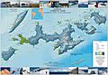
Topographic map of Livingston Island, Greenwich, Robert, Snow and Smith Islands.
