
Cecilia Island facts for kids

Cecilia Island from English Strait, with Mount Plymouth, Greenwich Island in the background
|
|

Location of Cecilia Island
|
|

Cecilia Island
Location in Antarctic Peninsula

Cecilia Island
Location in Antarctica
|
|
| Geography | |
|---|---|
| Location | Antarctica |
| Coordinates | 62°24′46.2″S 59°43′42.6″W / 62.412833°S 59.728500°W |
| Archipelago | Aitcho group |
| Area | 36 ha (89 acres) |
| Length | 910 m (2,990 ft) |
| Width | 450 m (1,480 ft) |
| Administration | |
| Administered under the Antarctic Treaty System | |
| Demographics | |
| Population | uninhabited |
Cecilia Island is a small, ice-free island located in Antarctica. It's the southernmost island in the Aitcho group, found on the west side of English Strait. The island is about 910 meters (about 0.56 miles) long and 450 meters (about 0.28 miles) wide. Its total area is around 36 hectares (about 89 acres).
In the early 1800s, American and English sealers visited this area. Today, Cecilia Island is a popular spot for tourists. Many Antarctic cruise ships stop here.
The island gets its name from the Cecilia, a small boat (called a shallop). This boat belonged to Captain John Davis. He visited the South Shetland Islands between 1820 and 1822. Captain Davis named the nearby English Strait "Cecilias Straits" after his boat. An important historical event happened from the Cecilia: the first known landing on the Antarctic mainland was made from this boat at Hughes Bay on February 7, 1821.
Where is Cecilia Island?
Cecilia Island is located at coordinates 62°24′46.2″S 59°43′42.6″W / 62.412833°S 59.728500°W. It's part of the South Shetland Islands in Antarctica.
The island is quite close to several other islands:
- It lies about 3.07 kilometers (1.9 miles) north of Spark Point on Greenwich Island.
- It's about 2.07 kilometers (1.28 miles) east-northeast of Dee Island.
- It's only about 280 meters (306 yards) southeast of Barrientos Island.
- It's also near Robert Island, located about 3.39 kilometers (2.1 miles) southwest of Debelyanov Point and 4.83 kilometers (3 miles) west of Negra Point.
Different countries have mapped this area over the years. These include Chile (1961), Britain (1968), Argentina (1980), and Bulgaria (2005 and 2009).
Images for kids
-
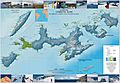
Topographic map of Livingston Island, Greenwich, Robert, Snow and Smith Islands.

