Holmes Rock facts for kids

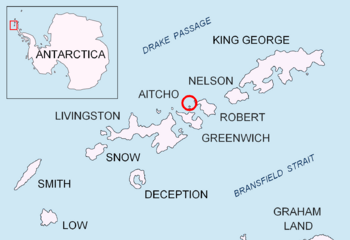
Location of Aitcho Islands in the South Shetland Islands.
|
|
|
Location of Holmes Rock
|
|
| Geography | |
|---|---|
| Location | Antarctica |
| Coordinates | 62°22′58.8″S 59°50′06″W / 62.383000°S 59.83500°W |
| Archipelago | South Shetland Islands |
| Administration | |
| Administered under the Antarctic Treaty System | |
| Demographics | |
| Population | Uninhabited |
Holmes Rock is a small rocky island in Antarctica. It stands about 45 meters (148 feet) tall. You can find it near Greenwich Island and the Aitcho group, which are all part of the South Shetland Islands. Long ago, in the early 1800s, seal hunters used to visit this area.
This rock is named after Captain Jeremiah Holmes. He was the captain of an American sealing ship called Emeline. Captain Holmes visited the South Shetland Islands in 1820-1821, and his ship often operated from a nearby place called Clothier Harbour.
Where is Holmes Rock?
Holmes Rock is located in a group of islands called the South Shetland Islands. It is about 2.3 kilometers (1.4 miles) west of Riksa Islands. It's also 2.1 kilometers (1.3 miles) west-northwest of Emeline Island.
You can find it about 1.53 kilometers (0.95 miles) north-northeast of Stoker Island. It is also 4.4 kilometers (2.7 miles) east-southeast of Romeo Island. Holmes Rock is separated from Nikudin Rock to its west-southwest by a narrow passage, only about 150 meters (492 feet) wide.
Mapping Holmes Rock
Different countries have created maps of Holmes Rock and the surrounding areas. These maps help us understand its exact location and features.
- L.L. Ivanov and others created a map called "Antarctica: Livingston Island and Greenwich Island, South Shetland Islands" in 2005.
- Another map by L.L. Ivanov, "Antarctica: Livingston Island and Greenwich, Robert, Snow and Smith Islands," was made in 2009.
 | William L. Dawson |
 | W. E. B. Du Bois |
 | Harry Belafonte |


