Riksa Islands facts for kids

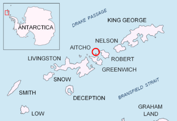
Where Riksa Island is located in the South Shetland Islands
|
|
|
Location of Riksa Island
|
|
| Geography | |
|---|---|
| Location | Antarctica |
| Coordinates | 62°23′05″S 59°46′49″W / 62.38472°S 59.78028°W |
| Archipelago | Aitcho group |
| Administration | |
| Administered under the Antarctic Treaty System | |
| Demographics | |
| Population | uninhabited |
The Riksa Islands are a group of three islands in Antarctica. They are called 'Ostrovi Riksa' in Bulgarian. These islands are special because they are mostly free of ice. They are part of the Aitcho group. You can find them on the west side of the English Strait.
The islands are located in the South Shetland Islands. They are about 250 meters (270 yards) west of Bilyana Island. They are also about 650 meters (710 yards) northeast of Emeline Island. Another island, Holmes Rock, is about 2.1 kilometers (1.3 miles) to their east. People who hunted seals visited this area a long time ago, in the early 1800s.
The Riksa Islands group includes three smaller islands. These are Cricklewood, Taunton, and Bath. Each island has its own special location.
Contents
Where Are the Riksa Islands Located?
The Riksa Islands are found at these coordinates: 62°23′05″S 59°46′49″W / 62.38472°S 59.78028°W. Bulgarian experts created maps of the area in 2009.
How the Islands Got Their Names
The Riksa Islands are named after two places in northwestern Bulgaria. These places are called Kamenna (Stone) Riksa and Lower Riksa.
Cricklewood Island
Cricklewood Island gets its name from a part of London, England. This is where the main office of the UKHO (United Kingdom Hydrographic Office) was located until 1968.
Taunton Island
Taunton Island is named after the town of Taunton in England. The UKHO's printing factory has been in Taunton since 1941. The rest of the UKHO office moved there in 1968.
Bath Island
Bath Island is named after the city of Bath in England. Some parts of the UKHO were temporarily moved to Bath during World War II.
 | Janet Taylor Pickett |
 | Synthia Saint James |
 | Howardena Pindell |
 | Faith Ringgold |


