Emeline Island facts for kids

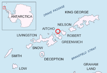
Location of Emeline Island in the South Shetland Islands
|
|
|
Location of Emeline Island
|
|
| Geography | |
|---|---|
| Location | Antarctica |
| Coordinates | 62°24′S 59°48′W / 62.400°S 59.800°W |
| Archipelago | Aitcho group |
| Area | 18 ha (44 acres) |
| Length | 0.55 km (0.342 mi) |
| Width | 0.32 km (0.199 mi) |
| Highest elevation | 100.0 m (328.1 ft) |
| Administration | |
| Administered under the Antarctic Treaty System | |
| Demographics | |
| Population | Uninhabited |
Emeline Island is a small, rocky island in Antarctica. It is part of the Aitcho group. This island is located on the west side of English Strait. It is one of the many islands in the South Shetland Islands.
Emeline Island rises to over 100 meters (328 feet) high. The island is about 550 meters (1,804 feet) long. It is also about 320 meters (1,050 feet) wide. Its total surface area is about 18 hectares (44 acres). No one lives on Emeline Island. Seal hunters visited this area a long time ago in the early 1800s.
How Emeline Island Got Its Name
This island is named after an American ship. The ship was called the Emeline. Its captain was Jeremiah Holmes. The Emeline visited the South Shetland Islands in 1820 and 1821. The ship often operated from a nearby place called Clothier Harbour.
Where is Emeline Island Located?
Emeline Island is found at coordinates 62°23′29.3″S 59°47′35″W. It is located near several other islands. For example, it is about 650 meters (711 yards) northwest of Pasarel Island. It is also about 1.8 kilometers (1.1 miles) northwest of Barrientos Island. Other nearby islands include Dee Island and Sierra Island.
Maps of the Area
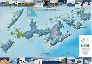
You can find Emeline Island on detailed maps of Antarctica. One useful map is:
- L.L. Ivanov et al. Antarctica: Livingston Island and Greenwich Island, South Shetland Islands. This is a topographic map with a scale of 1:100000. It was created by the Antarctic Place-names Commission of Bulgaria in 2005.
 | Jessica Watkins |
 | Robert Henry Lawrence Jr. |
 | Mae Jemison |
 | Sian Proctor |
 | Guion Bluford |


