Potmess Rocks facts for kids

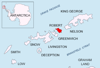
Location of Robert Island in the South Shetland Islands
|
|
|
Location of Potmess Rocks
|
|
| Geography | |
|---|---|
| Location | Antarctica |
| Coordinates | 62°19′07″S 59°45′16″W / 62.31861°S 59.75444°W |
| Archipelago | South Shetland Islands |
| Administration | |
| Administered under the Antarctic Treaty System | |
| Demographics | |
| Population | uninhabited |
The Potmess Rocks are a group of large rocks found near Robert Island in the South Shetland Islands. These islands are located in Antarctica, a very cold continent at the bottom of the world. The Potmess Rocks stretch about 1.3 kilometers (0.8 miles) long and 1 kilometer (0.6 miles) wide. They include some noticeable rocks called Asses Ears in the northern part. Long ago, in the early 1800s, people who hunted seals visited this area from a nearby place called Clothier Harbour.
Where are the Potmess Rocks?
The Potmess Rocks are located at 62°19′07″S 59°45′16″W / 62.31861°S 59.75444°W. To help you imagine where they are, they are about 3 kilometers (1.9 miles) west of Heywood Island. They are also about 2.9 kilometers (1.8 miles) northwest of Rogozen Island. If you travel further, they are 6.06 kilometers (3.77 miles) north-northwest of Fort William and 3.28 kilometers (2.04 miles) northeast of Table Island. Many countries, including Britain, Argentina, Chile, and Bulgaria, have mapped this area over the years.
How did the Potmess Rocks get their name?
The name "Potmess Rocks" has a fun and unusual story! It comes from a type of stew that was served for lunch on a boat called the Nimrod. This happened during a survey by the Royal Navy in 1967. A survey is when people carefully map and study an area. The stew was called "potmess," and the name stuck to these rocks!
 | Jewel Prestage |
 | Ella Baker |
 | Fannie Lou Hamer |


