Rossmoor, New Jersey facts for kids
Quick facts for kids
Rossmoor, New Jersey
|
|
|---|---|

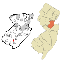
Map of Rossmoor highlighted within Middlesex County. Right: Location of Middlesex County in New Jersey.
|
|
| Country | |
| State | |
| County | Middlesex |
| Township | Monroe |
| Area | |
| • Total | 0.918 sq mi (2.378 km2) |
| • Land | 0.904 sq mi (2.343 km2) |
| • Water | 0.014 sq mi (0.035 km2) 1.48% |
| Elevation | 131 ft (40 m) |
| Population | |
| • Total | 2,666 |
| • Density | 2,947.6/sq mi (1,138.1/km2) |
| Time zone | UTC-5 (Eastern (EST)) |
| • Summer (DST) | UTC-4 (Eastern (EDT)) |
| Area code(s) | 609 |
| FIPS code | 3464865 |
| GNIS feature ID | 02389783 |
Rossmoor is a special kind of community in Monroe Township, Middlesex County, New Jersey. It is called an unincorporated community and a census-designated place (CDP). This means it's a specific area recognized by the government for counting people, but it doesn't have its own separate local government like a town. In 2010, about 2,666 people lived there.
Rossmoor is a gated community. This means it has controlled entrances, often with gates or security. It is also an age-restricted place, mostly for adults aged 55 and older. It's designed for active adults.
The community covers about 418 acres (1.7 square kilometers). It is located near Exit 8A of the New Jersey Turnpike. Rossmoor has 2,303 homes. These homes are built around a large 104-acre (0.4 square kilometer) championship golf course.
You can find many types of homes in Rossmoor. They range from smaller units of 500 square feet (46 square meters) to larger ones with 2,300 square feet (214 square meters). The buildings mostly look like American Colonial style homes. Many people who live in Rossmoor still work in the area. Some even travel to New York City for work. Express buses stop at Rossmoor, making it easy to get to the Port Authority Bus Terminal in Midtown Manhattan in about 55 minutes.
Contents
Exploring Rossmoor's Location and Size
Rossmoor is located in New Jersey. It is part of Middlesex County. The community is officially recognized by the United States Census Bureau.
How Big is Rossmoor?
The total area of Rossmoor is about 0.918 square miles (2.378 square kilometers). Most of this area is land, which is about 0.904 square miles (2.343 square kilometers). A small part of Rossmoor is water. This water area is about 0.014 square miles (0.035 square kilometers). So, about 1.48% of Rossmoor is covered by water.
Understanding Rossmoor's Population Changes
The number of people living in Rossmoor has changed over the years. This section looks at how the population has grown or shrunk.
Population Over the Years
Here's a quick look at how many people lived in Rossmoor during different census years:
| Historical population | |||
|---|---|---|---|
| Census | Pop. | %± | |
| 1990 | 3,231 | — | |
| 2000 | 3,129 | −3.2% | |
| 2010 | 2,666 | −14.8% | |
| Population sources: 2000 2010 | |||
Who Lives in Rossmoor?
In 2000, there were 3,129 people living in Rossmoor. Most of the people were White, making up about 97.95% of the population. Other groups included African American (0.96%), Native American (0.10%), and Asian (0.51%). A small number of people were from other races or mixed races. About 0.51% of the population was Hispanic or Latino.
There were 2,131 households in Rossmoor. A household is a group of people living together. Most households (61.1%) were made up of just one person. Many of these single-person households (56.4%) were people aged 65 or older. The average household had about 1.40 people. The average family had about 2.03 people.
The population in Rossmoor was mostly older adults. About 89.5% of the people were 65 years old or older. The average age was 77 years. Only a very small number of people were under 18 (0.1%).
Income and Living Costs
In 2000, the average income for a household in Rossmoor was $33,104 per year. For families, the average income was $41,847 per year. The income per person in Rossmoor was $31,178. A small percentage of families (1.1%) and people (4.3%) lived below the poverty line. This means their income was below a certain level set by the government.
See also
 In Spanish: Rossmoor (Nueva Jersey) para niños
 | DeHart Hubbard |
 | Wilma Rudolph |
 | Jesse Owens |
 | Jackie Joyner-Kersee |
 | Major Taylor |

