
Roxburgh County facts for kids
Quick facts for kids RoxburghNew South Wales |
|||||||||||||||
|---|---|---|---|---|---|---|---|---|---|---|---|---|---|---|---|

Location in New South Wales
|
|||||||||||||||
|
|||||||||||||||

Roxburgh County is a historic area in New South Wales, Australia. It was one of the first 19 counties created in the region. Today, it is one of 141 special land divisions called cadastral divisions. These divisions help manage land ownership and boundaries.
Roxburgh County is located northeast of the city of Bathurst. It lies north and east of the Fish River, extending to where it meets the Turon River. The town of Sofala is within this county. The Gudgegong River forms its northern border.
Contents
What is Roxburgh County?
Roxburgh County was named in 1829. It got its name from a place in Scotland. This naming tradition was common for many early Australian counties.
Why are Counties Important?
Counties like Roxburgh were set up a long time ago. They helped the government keep track of land. This was important for farming and building new towns. Even today, these old county names are still used. They help people understand where land is located.
Geography of Roxburgh County
Roxburgh County covers a large area. It includes different types of landscapes. Rivers like the Fish River and Turon River flow through it. These rivers are important for the local environment. They also provide water for the region.
Towns and Rivers in the County
The historic town of Sofala is a key part of Roxburgh County. It is known for its gold mining history. The Gudgegong River marks the northern edge of the county. These natural features help define the county's boundaries.
Parishes in Roxburgh County
Within Roxburgh County, there are many smaller areas called parishes. These parishes are like smaller neighborhoods or districts. Each parish has its own name. They help organize the land even more. Many of these parishes are part of different local government areas today. These include the City of Lithgow, Mid-Western Regional Council, and Bathurst Regional Council.
Images for kids
-
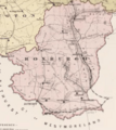
An old map showing the parishes within Roxburgh County.
_from_John_Sands_Atlas_of_Australiasia1886.png)
