Rum, Tyrol facts for kids
Quick facts for kids
Rum
|
||
|---|---|---|

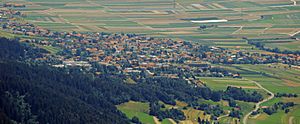
Rum seen from the northwest
|
||
|
||
| Country | Austria | |
| State | Tyrol | |
| District | Innsbruck Land | |
| Area | ||
| • Total | 8.56 km2 (3.31 sq mi) | |
| Elevation | 621 m (2,037 ft) | |
| Population
(2018-01-01)
|
||
| • Total | 9,190 | |
| • Density | 1,073.6/km2 (2,780.6/sq mi) | |
| Time zone | UTC+1 (CET) | |
| • Summer (DST) | UTC+2 (CEST) | |
| Postal code |
6063
|
|
| Area code | 0512 | |
| Vehicle registration | IL | |
| Website | www.rum.gv.at | |
Rum is a special kind of town called a market town in Austria. It got this title in 1987. You can find Rum in the state of Tyrol, right next to the city of Innsbruck. It's part of the Innsbruck Land area.
After World War II, Rum started to grow a lot. This happened because it is very close to Innsbruck. Many new businesses and factories were built in an area called Neu-Rum (which means New Rum). This area is right next to the Olympic Village part of Innsbruck. Because of all these new jobs and people moving in, Rum became one of the wealthiest towns in Tyrol. There's also an older area called Hoch-Rum (Upper Rum) which has a private hospital.
Even though Rum is its own town, it works very closely with Innsbruck. They share things like public services and transportation. There have been talks about Rum becoming officially part of Innsbruck, but so far, it has remained a separate town.
Rum's Growing Population
Rum has seen a big increase in the number of people living there over the years. This growth shows how popular the town has become, especially since the middle of the 20th century.
| Historical population | ||
|---|---|---|
| Year | Pop. | ±% |
| 1869 | 597 | — |
| 1880 | 572 | −4.2% |
| 1890 | 570 | −0.3% |
| 1900 | 599 | +5.1% |
| 1910 | 732 | +22.2% |
| 1923 | 784 | +7.1% |
| 1934 | 1,335 | +70.3% |
| 1939 | 1,497 | +12.1% |
| 1951 | 1,700 | +13.6% |
| 1961 | 3,180 | +87.1% |
| 1971 | 5,135 | +61.5% |
| 1981 | 7,650 | +49.0% |
| 1991 | 8,095 | +5.8% |
| 2001 | 8,352 | +3.2% |
| 2011 | 8,850 | +6.0% |
See also
 In Spanish: Rum (Austria) para niños
 | Frances Mary Albrier |
 | Whitney Young |
 | Muhammad Ali |


