Rutherglen Central and North (ward) facts for kids
Quick facts for kids Rutherglen Central and North |
|
|---|---|
| South Lanarkshire | |

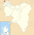
Boundary of Rutherglen Central and North in South Lanarkshire from 2007–2017.
|
|
| Population | 14,237 (2021) |
| Electorate | 11,692 (2022) |
| Major settlements | Rutherglen (part of) |
| Scottish Parliament constituency | Rutherglen |
| Scottish Parliament region | Glasgow |
| UK Parliament constituency | Rutherglen and Hamilton West |
| Current ward | |
| Created | 2007 |
| Number of councillors | 3 |
| Councillor | Martin Lennon (Labour) |
| Councillor | Janine Calikes (SNP) |
| Councillor | Andrea Cowan (SNP) |
| Created from | Bankhead Burgh Rutherglen West Stonelaw |
Rutherglen Central and North is one of the 20 areas for voting, called electoral wards, in South Lanarkshire Council. This ward was created in 2007. It chooses three local politicians, known as councillors. They are elected using a special voting method called the single transferable vote. The area has about 14,237 people living in it.
For a long time, from 2007 to 2017, the Scottish Labour Party usually won two out of the three councillor seats here. But in the 2022 election, the Scottish National Party (SNP) won two seats instead. This shows a change in how people in the area are voting.
Contents
What Are the Boundaries of Rutherglen Central and North?
This ward was created after a review of voting areas before the 2007 Scottish local elections. Because of a new law, local elections in Scotland started using the single transferable vote system from 2007. So, Rutherglen Central and North was formed by joining together several older wards. These older wards used a different voting system called first-past-the-post.
The new ward includes most of the old Bankhead ward. It also includes all of the old Burgh and Rutherglen West wards. A small part of the old Stonelaw ward was also added. Rutherglen Central and North is a suburban area in the northern part of Rutherglen. This is the most northern part of South Lanarkshire.
The ward includes neighbourhoods like Burgh, Bankhead, Burnhill, Gallowflat, and Farme Cross. It also has the Shawfield industrial area, which doesn't have people living in it. The northern and western edges of the ward follow the long-standing border with Glasgow City Council. Part of this border runs along the River Clyde.
In 2017, some streets around Overtoun Park, Dryburgh Avenue, and Limeside Avenue became part of this ward. These streets were moved from the Rutherglen South ward.
Who Are the Councillors for Rutherglen Central and North?
The councillors are the people elected to represent the ward. They work for the local council. Here's a look at who has been elected over the years:
| Election | Councillors | |||||||
|---|---|---|---|---|---|---|---|---|
| 2007 | Edward McAvoy (Labour) |
Denis McKenna (Labour) |
Gordon Clark (SNP) |
|||||
| 2012 | ||||||||
| 2017 | Gerard Killen (Labour) |
Jared Wark (Conservative) |
Janine Calikes (SNP) |
|||||
| 2017 by-election | Martin Lennon (Labour) |
|||||||
| 2022 | Andrea Cowan (SNP) |
|||||||
How Do Elections Work in Rutherglen Central and North?
Elections are held to choose the councillors for the ward. Here you can see the results from recent elections.
Results from the 2022 Election
2022 South Lanarkshire Council election
Results from the 2017 By-election
Sometimes, a special election called a by-election happens if a councillor leaves their job early. 2017 South Lanarkshire Council election
Results from the 2017 Election
2017 South Lanarkshire Council election
Results from the 2012 Election
2012 South Lanarkshire Council election
Results from the 2007 Election
2007 South Lanarkshire Council election
 | Ernest Everett Just |
 | Mary Jackson |
 | Emmett Chappelle |
 | Marie Maynard Daly |


