
Sabana, Vega Alta, Puerto Rico facts for kids
Quick facts for kids
Sabana
|
|
|---|---|
|
Barrio
|
|

Breñas Beach in Sabana
|
|

Location of Sabana within the municipality of Vega Alta shown in red
|
|

Sabana, Vega Alta, Puerto Rico
Location in Caribbean
|
|
| Commonwealth | |
| Municipality | |
| Area | |
| • Total | 9.10 sq mi (23.6 km2) |
| • Land | 8.33 sq mi (21.6 km2) |
| • Water | 0.77 sq mi (2.0 km2) |
| Elevation | 3 ft (0.9 m) |
| Population
(2010)
|
|
| • Total | 15,164 |
| • Density | 1,820.4/sq mi (702.9/km2) |
| Source: 2010 Census | |
| Time zone | UTC−4 (AST) |
Sabana is a neighborhood, also called a barrio, located in the town of Vega Alta, Puerto Rico. In 2010, about 15,164 people lived there. It covers an area of about 9.10 square miles. Sabana is known for its beautiful Breñas Beach.
Sabana's History and Growth
Sabana became part of the United States after the Spanish–American War. This happened because of an agreement called the Treaty of Paris of 1898. Puerto Rico then became an unincorporated territory of the U.S. This means it is a territory that belongs to the U.S. but is not fully part of it.
In 1899, the U.S. government counted the people living in Puerto Rico. This count, called a census, showed that 910 people lived in Sabana barrio at that time.
Sabana's population has grown a lot over the years. From 1990 to 2000, the number of people living there increased by 21.7%. Then, from 2000 to 2010, it grew even more, by 23.3%. This shows that more and more people have chosen to make Sabana their home.
| Historical population | |||
|---|---|---|---|
| Census | Pop. | %± | |
| 1900 | 910 | — | |
| 1910 | 1,059 | 16.4% | |
| 1920 | 1,423 | 34.4% | |
| 1930 | 1,871 | 31.5% | |
| 1940 | 2,531 | 35.3% | |
| 1950 | 3,013 | 19.0% | |
| 1960 | 4,208 | 39.7% | |
| 1980 | 9,072 | — | |
| 1990 | 10,108 | 11.4% | |
| 2000 | 12,300 | 21.7% | |
| 2010 | 15,164 | 23.3% | |
| U.S. Decennial Census 1899 (shown as 1900) 1910-1930 1930-1950 1960 1980-2000 2010 |
|||
Gallery
-
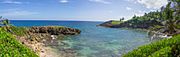
Breñas Beach in Sabana
-
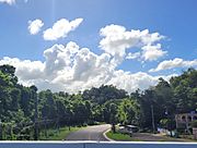
Puerto Rico Highway 690 in Sabana


See also
 In Spanish: Sabana (Vega Alta) para niños
- List of communities in Puerto Rico
