Sabanas de San Ángel facts for kids
Quick facts for kids
Sabanas de San Ángel
|
|||
|---|---|---|---|
|
town
|
|||
|
|||

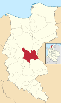
Location of the municipality and town of Sabanas de San Angel in the Department of Magdalena.
|
|||
| Country | Colombia | ||
| Region | Caribbean | ||
| Department | Magdalena | ||
| Foundation | circa 1607 | ||
| Area | |||
| • Total | 977 km2 (377 sq mi) | ||
| Population
(Census 2018)
|
|||
| • Total | 14,060 | ||
| • Density | 14.391/km2 (37.27/sq mi) | ||
| Time zone | UTC-5 | ||
| Website | www.sabanasdesanangel-magdalena.gov.co |
||
Sabanas de San Ángel is a town and a special area called a municipality in Colombia. It is located in the Magdalena Department. The name "Sabanas de San Ángel" means "Savannas of Saint Angel" in Spanish.
Contents
About Sabanas de San Ángel
Sabanas de San Ángel is a town and a municipality. A municipality is like a county or a local government area. This town is found in the Magdalena Department of Colombia. It is part of the Caribbean Region of Colombia.
How Big is the Area?
The total area of the Sabanas de San Ángel municipality is about 977 square kilometers. This is a good size for a local area in Colombia.
How Many People Live Here?
According to a census taken in 2018, about 14,060 people live in Sabanas de San Ángel. This number includes people living in the town and the surrounding rural areas.
History of Sabanas de San Ángel
Sabanas de San Ángel has a long history. It was first started a very long time ago, around the year 1607.
Early Beginnings
When it was first founded by Spanish explorers, it was called San Antoñito. It was an important stop for travelers. It served as a pathway town. This means it was a place where people could rest or pass through. It was on a route between the area of La Guajira Department and the big Magdalena River.
Becoming a Municipality
For many years, San Antoñito was part of other larger municipalities. But on June 24, 1999, something important happened. Sabanas de San Ángel officially became its own municipality. It was separated from parts of four other municipalities: Ariguaní, Pivijay, Chibolo, and Plato. This made it an independent local government area.
Government
Like all municipalities in Colombia, Sabanas de San Ángel has its own local government.
The Mayor
The main leader of the municipality is called the Mayor. The mayor is in charge of running the town and making decisions for the people who live there. They work to improve the community and provide services.
See also
 In Spanish: Sabanas de San Ángel para niños
 | Aurelia Browder |
 | Nannie Helen Burroughs |
 | Michelle Alexander |


