Sabattus, Maine facts for kids
Quick facts for kids
Sabattus, Maine
|
|
|---|---|

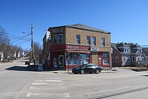
Main Street Market
|
|

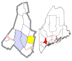
Location of Sabattus (in yellow) in Androscoggin County and the state of Maine
|
|
| Country | United States |
| State | Maine |
| County | Androscoggin |
| Villages | Sabattus Robinson Corner Webster Corner |
| Area | |
| • Total | 26.91 sq mi (69.70 km2) |
| • Land | 25.71 sq mi (66.59 km2) |
| • Water | 1.20 sq mi (3.11 km2) |
| Elevation | 325 ft (99 m) |
| Population
(2020)
|
|
| • Total | 5,044 |
| • Density | 196/sq mi (75.7/km2) |
| Time zone | UTC-5 (Eastern (EST)) |
| • Summer (DST) | UTC-4 (EDT) |
| ZIP code |
04280
|
| Area code(s) | 207 |
| FIPS code | 23-64570 |
| GNIS feature ID | 0582704 |
| Website | http://sabattus.org/ |
Sabattus is a town in Androscoggin County, Maine, United States. In 2020, about 5,044 people lived there. It is part of the larger Lewiston-Auburn area in Maine.
The town was once called "Webster." In 1971, its name changed to "Sabattus." This new name honors a Native American chief from the Anasagunticook tribe. The village of Sabattus is located in the northwest part of the town. It is found where Sabattus Pond flows out.
Contents
History of Sabattus
The town of Sabattus was officially created on March 7, 1840. It was separated from the nearby town of Lisbon. At first, it was named Webster.
The name Sabattus comes from a chief of a Native American tribe. This tribe used to live in the area a long time ago. They had moved away before settlers arrived. Only the lake, river, and a mountain in the area kept the name Sabattus. The spelling of the name changed over time to what it is today.
Geography of Sabattus
Sabattus covers a total area of about 26.91 square miles (69.70 square kilometers). Most of this area is land. About 25.71 square miles (66.59 square kilometers) is land.
A smaller part of the town is water. This includes lakes and rivers. About 1.20 square miles (3.11 square kilometers) of the town is water.
Education in Sabattus
Sabattus is part of the Regional School Unit 4 school district. This district serves several towns. Here are the schools that students from Sabattus attend:
- Oak Hill High School (Grades 9–12) – Located in Wales
- Oak Hill Middle School (Grades 6–8) – Located in Sabattus
- Carrie Ricker School (Grades 3–5) – Located in Litchfield
- Sabattus Primary School (Pre-Kindergarten–Grade 2) – Located in Sabattus
- Libby Tozier School (Pre-Kindergarten–Grade 2) – Located in Litchfield
Population of Sabattus
| Historical population | |||
|---|---|---|---|
| Census | Pop. | %± | |
| 1990 | 3,696 | — | |
| 2000 | 4,486 | 21.4% | |
| 2010 | 4,876 | 8.7% | |
| 2020 | 5,044 | 3.4% | |
| U.S. Decennial Census | |||
2010 Population Details
In 2010, there were 4,876 people living in Sabattus. These people lived in 1,979 homes. About 1,407 of these homes were families.
Most people in Sabattus were White (97.4%). A small number of people were from other racial backgrounds. About 1% of the population was of Hispanic or Latino origin.
Many homes (30.6%) had children under 18 living there. Most homes (53.7%) were married couples. The average home had about 2.46 people. The average family had about 2.80 people.
The average age of people in Sabattus was 42 years old. About 21.4% of residents were under 18. About 14.1% were 65 years or older. The town had a nearly equal number of males (49.7%) and females (50.3%).
Notable Person from Sabattus
- Gleason Archer, Sr. – He was famous for starting Suffolk University and its Law School.
See also

 | Percy Lavon Julian |
 | Katherine Johnson |
 | George Washington Carver |
 | Annie Easley |


