Safenwil facts for kids
Quick facts for kids
Safenwil
|
||
|---|---|---|
|
||
| Country | Switzerland | |
| Canton | Aargau | |
| District | Zofingen | |
| Area | ||
| • Total | 5.99 km2 (2.31 sq mi) | |
| Elevation | 483 m (1,585 ft) | |
| Population
(Dec 2020 )
|
||
| • Total | 4,107 | |
| • Density | 685.6/km2 (1,775.8/sq mi) | |
| Postal code |
5745
|
|
| Surrounded by | Gretzenbach (SO), Kölliken, Oftringen, Uerkheim, Walterswil (SO), Zofingen | |
Safenwil is a small town, also called a municipality, located in Switzerland. It is part of the Zofingen district in the canton of Aargau. Safenwil is known for its interesting history and its important location for transportation.
Exploring Safenwil's Past
Safenwil has a long and exciting history, going back thousands of years. Let's discover how this town grew from ancient times!
Early Settlements and Ancient Markings
The very first people in the Safenwil area were from the Roman era. They built an estate, like a large farm, along a path used by mules. This path connected the Wigger valley to a Roman town called Vindonissa.
After the Romans, a small camp or village of the Alamanni people was built here. You can still see ancient rock carvings called the Eberkopf (which means "Boar's Head"). These carvings are very old, dating back to 893 AD.
How Safenwil Got Its Name
The modern village of Safenwil was first mentioned in official records in 924 AD. Back then, it was known as Sabenewilare. Over time, the name changed to what we know today.
Who Ruled Safenwil?
In the 1200s, the village was controlled by a family from a place called Belp. Later, in the 1300s, the Ifenthal family took over. They ruled Safenwil from their castle, Scherenberg castle.
In 1415, a big change happened. The powerful city of Bern took control of the Aargau region, including Safenwil. Under Bern's rule, Safenwil became part of the Lenzburg District. Bern was in charge of serious legal matters, like major crimes. For smaller local issues, another place called Gösgen in Solothurn had the power after 1458. But by 1665, Bern took over all legal rights in Safenwil.
Becoming Part of Aargau
In 1803, Switzerland formed new cantons. Safenwil became part of the new Aargau canton and was placed in the Zofingen district. This is still its home today.
Schools Through the Ages
Education has always been important in Safenwil. The town has built several school houses over the years. The first one was built in 1730. New schools were also built in 1829–30, 1908, 1969, and most recently in 1999.
Churches and Religious Life
In 1304, a monastery from Zofingen built a chapel in Safenwil called St. Ulrich's Chapel. However, during the Protestant Reformation, this chapel was destroyed by Bern.
Before the Reformation, Safenwil was part of the Gretzenbach parish (a church district). From 1528 to 1616, it belonged to the Zofingen parish. After 1616, it became part of the Kölliken parish. Finally, in 1865, Safenwil became its own independent parish and built its own church in 1866-67.
Safenwil's Growth and Economy
Safenwil's location has helped it grow and become an important place for businesses.
Connecting Safenwil: Roads and Railways
Around 1770, Bern built a major road that went through Safenwil. This road connected Bern to Zurich. This was a big step for the town!
Later, in 1877, the Swiss Federal Railways built a train line that included Safenwil. This line connected Aarau to Zofingen. Having a train station made it even easier for people and goods to travel.
Since 1967, the A1 motorway, a major highway, also passes through the town. These excellent transportation links have helped Safenwil grow a lot.
From Factories to Services
The good transportation links encouraged factories to open in Safenwil. Around 1820, the first factory started. It was a weaving and dyeing factory called Hüssy. This factory operated for over 100 years, closing in 1934. In 1897, another factory, Hochuli, which made knitted goods, opened near the train station.
Throughout the 19th and 20th centuries, more factories opened in Safenwil. Many residents also worked in factories in nearby towns like Zofingen and Schönenwerd. In 1920, most jobs (75%) were in factories, while only 14% were in farming.
However, things have changed a lot since then. By 2005, most of the big factories had moved away. Now, only about 19% of jobs are in industry. A much larger number, 77%, are in the services sector. This means people work in jobs like retail, offices, or other services.
A very important company for Safenwil is Emil Frey. This company, which imports cars, moved to the municipality in 1951. It employs around 230 people and plays a big role in the local job market.
Safenwil's Geography
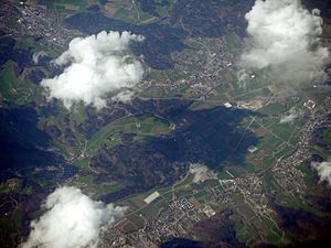
Safenwil covers an area of about 5.99 square kilometers (2.31 square miles). Let's look at how this land is used.
Land Use in Safenwil
- Farmland: About 27.7% of Safenwil's land is used for farming. This includes fields for growing crops and pastures where animals graze.
- Forests: A large part of the municipality, about 45.9%, is covered by forests. These are mostly dense, thick woods.
- Buildings and Roads: Around 26.9% of the land is developed. This includes buildings like homes and businesses, as well as roads and other transportation areas.
- Unused Land: A very small amount, about 0.2%, is unproductive land, meaning it's not used for anything specific.
Within the built-up areas, industrial buildings make up 5.0% of the total area. Homes and other buildings take up 13.0%, and roads and other transport areas make up 7.2%.
Location and Borders
Safenwil is located in the Zofingen district. It sits between the lower valleys of two rivers, the Wigger and the Suhre. The northern border of Safenwil is shared with the Canton of Solothurn.
See also
In Spanish: Safenwil para niños
 | John T. Biggers |
 | Thomas Blackshear |
 | Mark Bradford |
 | Beverly Buchanan |


