
Sag Harbor Hills, Azurest, and Ninevah Beach Subdivisions Historic District facts for kids
Quick facts for kids |
|
|
Sag Harbor Hills, Azurest, and Ninevah Beach Subdivisions Historic District
|
|

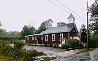
SANS Heritage House, September 2020
|
|

Location in New York

Location in the United States
|
|
| Location | Roughly bounded by Hempstead St., Richards Dr., Hampton St., Lincoln St., Harding Terr., Terry Dr. & the eastern end of Haven's Beach, Sag Harbor, New York |
|---|---|
| Architect | Amaza Lee Meredith; unknowns |
| NRHP reference No. | 100004217 |
| Added to NRHP | July 10, 2019 |
The Sag Harbor Hills, Azurest, and Ninevah Beach Subdivisions Historic District (SANS) is a special beachfront area in Sag Harbor, New York. It was created by and for African Americans after World War II.
During a time when Black families faced unfair rules (called Jim Crow laws), they often couldn't go to many beaches or resorts. SANS became a safe and welcoming summer getaway for middle-class African American families. It was a place where they could relax and enjoy the beach without facing racism.
This historic district is found near Hempstead Street, Richards Drive, Hampton Street, Lincoln Street, Harding Terrace, Terry Drive, and the eastern part of Haven's Beach in Sag Harbor. It was added to the National Register of Historic Places on July 10, 2019, recognizing its important history.

Contents
The Start of a Special Place

Long ago, the area north-west of East Hampton village was home to free Black and Native American people. They lived in a community called Eastville. In 1839, the African Methodist Church of Eastville built a church and cemetery there. This cemetery, called St. David African Methodist Episcopal Zion Cemetery, welcomed Irish immigrants, Montauketts, and African Americans.
The idea for SANS began in the late 1940s. African American families started buying land for summer homes. They often built small cottages on large plots. Many of these families were doctors, lawyers, business owners, and artists.
How Azurest Began
A schoolteacher from Brooklyn, Maude Terry, had a great idea while on vacation in Eastville. She imagined a private community for Black families. This community would be on a 20-acre piece of land between Hampton Street and Gardiner's Bay.
Maude's sister, Amaza Lee Meredith, was a Black architect. She helped plan how to divide the land into smaller lots. Their family still owns two cottages in the community today.
Growing into a Popular Spot
As the 1950s and 1960s arrived, more families came to SANS. Famous people like Lena Horne and Harry Belafonte also visited. The community became a popular vacation spot for Black families, much like Oak Bluffs in Massachusetts.
Over 300 Black families bought land. This led to the creation of two more communities next to Azurest: Sag Harbor Hills and Ninevah Beach. These areas were connected by dirt roads.
Summer Fun in SANS

Paul Ruffins, a former editor for the NAACP's The Crisis magazine, spent his summers at Ninevah Beach. He remembers a time when the number of people in SANS would grow to 1,000 each summer. This was important for Sag Harbor, especially when local factories closed down.
Ruffins recalls a peaceful time. Sunglasses left on the beach would still be there the next day. Kids would explore the woods and meet other children whose families had helped start the community. Many firefighters and teachers bought lots here, creating a strong community.
Families built their homes, sometimes even using plans from Popular Mechanics magazine. The beach was gentle, with calm waters from Gardiner's Bay. It was a short walk to town for ice cream. The area had clean sand, sailboats, and beautiful trees like sassafras and cedar. These trees created a special feeling, helping a generation of African Americans enjoy their "Soul of Summer."
Keeping SANS Special
.jpg)


Because SANS is close to East Hampton, some people are trying to buy properties from older residents. They want to build very large houses, which don't fit the original, smaller homes of the community. House prices in the Hamptons have gone up a lot. Sag Harbor Hills and Ninevah are now seen as places where investors can find "bargains."
For example, one developer bought nine pieces of land. They wanted to build a house that was 5,300 square feet. This is much bigger than the average house size in the area, which is about 1,378 square feet. Homeowners in SANS are working together to protect their community's unique character.
Famous Visitors and Residents
Many interesting people have visited or lived in SANS:
- Olivia Ward Bush-Banks: A writer who wrote about the Montaukett people.
- Langston Hughes: A famous writer and poet from the Harlem Renaissance. He visited often in the 1950s.
- Gloria Naylor: A writer known for her stories about African-American women.
- Daisy Tapley: A classical performer and activist.
- Edward R. Dudley: A former Manhattan Borough President and Ambassador to Liberia.
- Renee V. H. Simons: She led the effort to make SANS a historic district.
- William Pickens: A well-known speaker and former secretary of the NAACP.
- Colson Whitehead: An American novelist.
- Reynold Ruffins: An American painter, illustrator, and graphic designer.
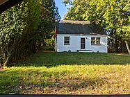
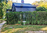
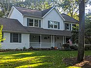
Gallery
-
St. David AME Zion Church
-
Azurest
-
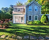
Home in Azurest
-
Azurest
-
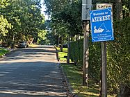
Azurest sign
-
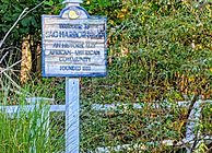
Sag Harbor Hills sign
-
Azurest home


.jpg)


