Saint-Étienne-du-Grès facts for kids
Quick facts for kids
Saint-Étienne-du-Grès
|
||
|---|---|---|

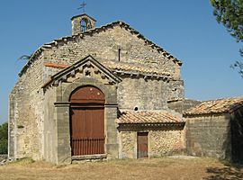
Notre-Dame du Château Chapel
|
||
|
||
| Country | France | |
| Region | Provence-Alpes-Côte d'Azur | |
| Department | Bouches-du-Rhône | |
| Arrondissement | Arles | |
| Canton | Tarascon | |
| Area
1
|
29.04 km2 (11.21 sq mi) | |
| Population
(2008)
|
2,152 | |
| • Density | 74.105/km2 (191.93/sq mi) | |
| Time zone | UTC+01:00 (CET) | |
| • Summer (DST) | UTC+02:00 (CEST) | |
| INSEE/Postal code |
13094 /13103
|
|
| Elevation | 5–231 m (16–758 ft) (avg. 10 m or 33 ft) |
|
| 1 French Land Register data, which excludes lakes, ponds, glaciers > 1 km2 (0.386 sq mi or 247 acres) and river estuaries. | ||
Saint-Étienne-du-Grès is a small and friendly village, also known as a commune, located in the sunny south of France. It is part of the Provence-Alpes-Côte d'Azur region and can be found in the Bouches-du-Rhône department. In 2008, about 2,152 people lived there.
Contents
Where Is Saint-Étienne-du-Grès?
This lovely commune is situated in the south of France. It's part of the larger Arles area. The village is close to the city of Tarascon.
What Is the Area Like?
Saint-Étienne-du-Grès is quite flat in some parts, with an average height of 10 meters (about 33 feet) above sea level. However, it also has higher areas, reaching up to 231 meters (about 758 feet). The total area of the commune is about 29 square kilometers (11 square miles).
Who Is in Charge?
Like many towns, Saint-Étienne-du-Grès has a mayor who helps run the village. From 2008 to 2014, the mayor was Robert Del Testa. The mayor and a local council make decisions for the community.
Images for kids
See also
 In Spanish: Saint-Étienne-du-Grès para niños
 | Frances Mary Albrier |
 | Whitney Young |
 | Muhammad Ali |


