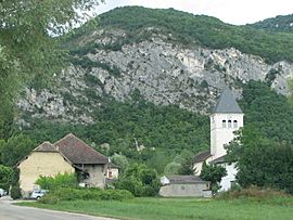
Saint-Benoît, Ain facts for kids
Quick facts for kids
Saint-Benoit
|
|
|---|---|
|
Part of Groslée-Saint-Benoît
|
|
 |
|
| Country | France |
| Region | Auvergne-Rhône-Alpes |
| Department | Ain |
| Arrondissement | Belley |
| Canton | Belley |
| Commune | Groslée-Saint-Benoît |
| Area
1
|
21.65 km2 (8.36 sq mi) |
| Population
(2021)
|
916 |
| • Density | 42.31/km2 (109.58/sq mi) |
| Time zone | UTC+01:00 (CET) |
| • Summer (DST) | UTC+02:00 (CEST) |
| Postal code |
01300
|
| Elevation | 201–778 m (659–2,552 ft) (avg. 206 m or 676 ft) |
| 1 French Land Register data, which excludes lakes, ponds, glaciers > 1 km2 (0.386 sq mi or 247 acres) and river estuaries. | |
Saint-Benoit was a small town, also known as a commune, located in eastern France. It was part of the Ain department. Think of a department like a county or a larger region within a country.
On January 1, 2016, Saint-Benoit joined with another commune called Groslée. Together, they formed a new, larger commune named Groslée-Saint-Benoît. This merger helped combine resources and services for the people living there.
Population Changes Over Time
The number of people living in Saint-Benoit changed over the years. Understanding population numbers helps us see how a place grows or shrinks.
| Historical population | ||
|---|---|---|
| Year | Pop. | ±% p.a. |
| 2006 | 705 | — |
| 2011 | 792 | +2.35% |
| 2021 | 916 | +1.47% |
| Source: INSEE | ||
As you can see from the numbers, the population of Saint-Benoit grew steadily before it merged. In 2006, about 705 people lived there. By 2021, this number had increased to 916 residents.
Learn More
 You can find more information about Saint-Benoit (Ain) for kids in Spanish by visiting this link: Saint-Benoît (Ain) para niños
 | Lonnie Johnson |
 | Granville Woods |
 | Lewis Howard Latimer |
 | James West |


