
Saint-Pierre-sur-Erve facts for kids
Quick facts for kids
Saint-Pierre-sur-Erve
|
|
|---|---|
 |
|

Saint-Pierre-sur-Erve
Location in France

Saint-Pierre-sur-Erve
Location in Pays de la Loire
|
|
| Country | France |
| Region | Pays de la Loire |
| Department | Mayenne |
| Arrondissement | Laval |
| Canton | Sainte-Suzanne |
| Intercommunality | Erve et Charnie |
| Area
1
|
9.74 km2 (3.76 sq mi) |
| Population
(2005)
|
138 |
| • Density | 14.17/km2 (36.70/sq mi) |
| Time zone | UTC+01:00 (CET) |
| • Summer (DST) | UTC+02:00 (CEST) |
| INSEE/Postal code |
53248 /53270
|
| Elevation | 57–116 m (187–381 ft) (avg. 82 m or 269 ft) |
| 1 French Land Register data, which excludes lakes, ponds, glaciers > 1 km2 (0.386 sq mi or 247 acres) and river estuaries. | |
Saint-Pierre-sur-Erve is a small commune (a type of town or village) located in the Mayenne department in the northwest of France. It is part of the Pays de la Loire region. In 2005, about 138 people lived there.
Contents
What is Saint-Pierre-sur-Erve?
Saint-Pierre-sur-Erve is a quiet place in the French countryside. It is known for its peaceful setting. The commune is part of a larger area called the Erve et Charnie intercommunality. This means it works with nearby towns on shared projects.
Where is Saint-Pierre-sur-Erve Located?
This commune is found in the western part of France. It is in the Mayenne department, which is known for its green landscapes. The nearest large city is Laval.
How Big is Saint-Pierre-sur-Erve?
The total area of Saint-Pierre-sur-Erve is about 9.74 square kilometers. This is roughly 3.76 square miles. The land here ranges in height from 57 meters (187 feet) to 116 meters (381 feet) above sea level.
Who Leads Saint-Pierre-sur-Erve?
Like all communes in France, Saint-Pierre-sur-Erve has a mayor. The mayor is the head of the local government. From 2008 to 2014, Marcel Mottais was the mayor. The mayor helps manage the town and its services for the people living there.
Images for kids
-
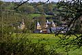
A view of Saint-Pierre-sur-Erve.
See also
 In Spanish: Saint-Pierre-sur-Erve para niños
