
Saint-Rémy-en-Rollat facts for kids
Quick facts for kids
Saint-Rémy-en-Rollat
|
||
|---|---|---|
 |
||
|
||

Saint-Rémy-en-Rollat
Location in France

Saint-Rémy-en-Rollat
Location in Auvergne-Rhône-Alpes
|
||
| Country | France | |
| Region | Auvergne-Rhône-Alpes | |
| Department | Allier | |
| Arrondissement | Vichy | |
| Canton | Escurolles | |
| Intercommunality | Vichy Val d'Allier | |
| Area
1
|
20.84 km2 (8.05 sq mi) | |
| Population
(2008)
|
1,601 | |
| • Density | 76.82/km2 (198.97/sq mi) | |
| Time zone | UTC+01:00 (CET) | |
| • Summer (DST) | UTC+02:00 (CEST) | |
| INSEE/Postal code |
03258 /03110
|
|
| Elevation | 239–333 m (784–1,093 ft) (avg. 262 m or 860 ft) |
|
| 1 French Land Register data, which excludes lakes, ponds, glaciers > 1 km2 (0.386 sq mi or 247 acres) and river estuaries. | ||
.svg)
Saint-Rémy-en-Rollat is a small and friendly commune (which is like a town or village) located in the center of France. It is found in the Allier department, a region known for its beautiful landscapes. This village is a quiet place where about 1,600 people live.
Contents
About Saint-Rémy-en-Rollat
Where is Saint-Rémy-en-Rollat?
Saint-Rémy-en-Rollat is in the Allier department. This department is part of the Auvergne-Rhône-Alpes region in central France. The village is close to the city of Vichy.
What is a Commune?
In France, a commune is the smallest unit of local government. It's like a town or a village. Each commune has its own mayor and local council. They manage local services for the people living there.
Who is the Mayor?
The mayor of Saint-Rémy-en-Rollat is Jean-Claude Martinet. A mayor is the leader of the local government. They help make decisions for the community. This includes things like managing local schools, roads, and public spaces.
How Big is the Village?
Saint-Rémy-en-Rollat covers an area of about 20.84 square kilometers (which is about 8 square miles). The village is located at an elevation of about 262 meters (860 feet) above sea level. Its lowest point is 239 meters, and its highest is 333 meters.
Images for kids
-
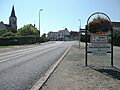
The entrance to Saint-Rémy-en-Rollat.
See also
 In Spanish: Saint-Rémy-en-Rollat para niños
