
Saint Andrew, Guernsey facts for kids
Quick facts for kids
St. Andrew
|
||
|---|---|---|
|
||

Location of St. Andrew in Guernsey
|
||
| Crown Dependency | Guernsey, Channel Islands | |
| Area | ||
| • Total | 4.4 km2 (1.7 sq mi) | |
| Population
(2019)
|
||
| • Total | 2,295 | |
| • Density | 522/km2 (1,351/sq mi) | |
| Time zone | GMT | |
| • Summer (DST) | UTC+01 | |

Saint Andrew (called Saint Andri in Guernésiais and Saint-André-de-la-Pommeraye in French) is a special place right in the middle of Guernsey. It's the only parish on the island that doesn't touch the sea!
Because it's usually listed last when talking about Guernsey's parishes, people from Saint Andrew have a fun nickname in the local language, Dgèrnésiais: les croinchaons. This means "the siftings," like the bits left behind in a sieve.
Contents
Exploring Saint Andrew Parish
Saint Andrew is located in the very center of the island. It has a mix of hills and valleys, making it a beautiful place to explore. The parish is divided into two main parts. One part is next to St Peter Port, and the other borders St Saviour and the Forest.
Rural Life and Agriculture
The upper part of Saint Andrew, where the main church and the famous Little Chapel are, feels very rural. This means it's mostly countryside with farms and open spaces. The parish is mainly used for farming, growing crops and raising animals. There's also a place called Best's quarry, which is now used to store water for the island.
Property and Postcodes
Saint Andrew is known for having some of the most expensive properties to buy in Guernsey. The postal code for addresses in this parish starts with GY6.
What Can You Find in Saint Andrew?
Saint Andrew is home to many interesting places and important buildings.
Churches and Chapels
- Saint Andrew parish church: This is the main church for the parish.
- The Monnaie Chapel: Another place of worship in the area.
- La Villiaze Church: A third church found within the parish.
- The Little Chapel: This tiny, beautiful chapel is famous! Many people believe it's the smallest consecrated church in the world. It's decorated with broken china and shells.
Historical and Military Sites
- Parish war memorial: You can find this inside the main church. It remembers people from the parish who served in wars.
- German Military Underground Hospital: During World War II (1940-1945), German forces occupied Guernsey. They built a large underground hospital here.
- German fortifications: There are also other defensive structures built by the Germans during their occupation.
Other Important Features
- Abreuvoirs: These are special places where farm animals, like cows, used to go to drink water.
- Protected buildings: Many buildings in Saint Andrew are protected, meaning they are important for their history or architecture and cannot be changed without special permission.
Key Institutions and Services
The parish of Saint Andrew also hosts several important organizations and facilities:
- St Andrew Douzaine: This is a local government body that helps manage the parish.
- Princess Elizabeth Hospital: The main hospital for Guernsey is located here.
- Les Bourgs Hospice: A special place that provides care for people with serious illnesses.
- Grammar School: A well-known secondary school.
- Blanchelande College: Another independent school in the parish.
- Specsavers Optical Group: The headquarters for this large eyewear company.
- St Andrew water storage reservoir: This is where a lot of the island's water is stored.
- Various hotels and restaurants: Places where visitors can stay and eat.
Gallery
-
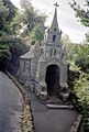
Little Chapel, Guernsey
-
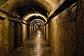
German underground hospital
.jpg)

See also
 In Spanish: Saint Andrew (Guernsey) para niños
