Forest, Guernsey facts for kids
Quick facts for kids
Forest
|
||
|---|---|---|

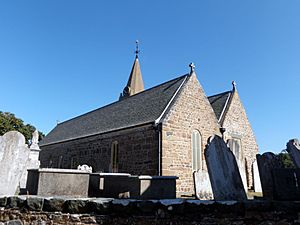
Ste Marguerite de la Foret parish church
|
||
|
||

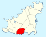
Location of Forest in Guernsey
|
||
| Crown Dependency | Guernsey, Channel Islands | |
| Area | ||
| • Total | 4.2 km2 (1.6 sq mi) | |
| Population | ||
| • Total | 1,546 | |
| • Density | 368/km2 (953/sq mi) | |
| Time zone | GMT | |
| • Summer (DST) | UTC+01 | |
The Forest (also known as La Fouarêt in Guernésiais and La Forêt in French) is a special area called a parish in Guernsey. It is the highest parish on the island, reaching about 100 meters above sea level. Its full name, Ste Marguerite de la Foret, comes from its main church.
Long ago, people from La Fouarêt were nicknamed bourdaons, which means "bumblebees." This was a fun local way to describe them.
If you send mail to someone in Forest, the postal code for their address will start with GY8.
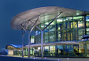
Forest was also the first part of the island to experience the arrival of German forces during World War II. On June 30, 1940, German soldiers landed at the Airport in Forest. This marked the start of the occupation of the island.
Contents
Exploring Forest's Geography
Forest is located on the southern side of Guernsey. It shares borders with several other parishes. To the west, it meets St Peter's. To the north-west, it borders St Saviour's. On its northern side, you'll find St Andrew's, and to the east, it connects with St Martin's.
Beaches and Coastal Views
The southern coast of Forest is mostly made up of tall, steep cliffs. However, there are a couple of beaches you can find here:
- Le Portelet: This beach is hard to reach from land. You can get there by swimming from Petit Bôt or by taking a boat.
- Part of Petit Bôt: This is another section of beach along the coast.
Understanding Forest's Landscape
Forest is known for being the highest point on the island, reaching about 100 meters. The only lower areas are right along the coast. Even there, you'll find dramatic, steep cliffs rather than flat land.
Weather in Forest: A Look at the Climate
The official weather station for Guernsey has been located at Guernsey Airport in Forest since 1939. This station collects all the important weather data for the island.
| Climate data for Forest, Guernsey (Guernsey Airport) | |||||||||||||
|---|---|---|---|---|---|---|---|---|---|---|---|---|---|
| Month | Jan | Feb | Mar | Apr | May | Jun | Jul | Aug | Sep | Oct | Nov | Dec | Year |
| Record high °C (°F) | 13.3 (55.9) |
15.0 (59.0) |
19.4 (66.9) |
24.3 (75.7) |
25.9 (78.6) |
30.8 (87.4) |
31.7 (89.1) |
34.3 (93.7) |
30.6 (87.1) |
23.6 (74.5) |
16.8 (62.2) |
15.6 (60.1) |
34.3 (93.7) |
| Mean daily maximum °C (°F) | 8.7 (47.7) |
8.4 (47.1) |
10.0 (50.0) |
11.8 (53.2) |
14.9 (58.8) |
17.5 (63.5) |
19.5 (67.1) |
19.8 (67.6) |
18.0 (64.4) |
15.1 (59.2) |
11.8 (53.2) |
9.5 (49.1) |
13.8 (56.8) |
| Daily mean °C (°F) | 6.9 (44.4) |
6.5 (43.7) |
7.8 (46.0) |
9.2 (48.6) |
12.1 (53.8) |
14.5 (58.1) |
16.6 (61.9) |
17.0 (62.6) |
15.5 (59.9) |
13.0 (55.4) |
10.0 (50.0) |
7.8 (46.0) |
11.4 (52.5) |
| Mean daily minimum °C (°F) | 5.0 (41.0) |
4.6 (40.3) |
5.6 (42.1) |
6.6 (43.9) |
9.2 (48.6) |
11.5 (52.7) |
13.6 (56.5) |
14.1 (57.4) |
12.9 (55.2) |
10.8 (51.4) |
8.1 (46.6) |
6.0 (42.8) |
9.0 (48.2) |
| Record low °C (°F) | −7.8 (18.0) |
−7.2 (19.0) |
−2.2 (28.0) |
−1.4 (29.5) |
0.1 (32.2) |
5.4 (41.7) |
8.3 (46.9) |
9.2 (48.6) |
5.8 (42.4) |
3.5 (38.3) |
−0.8 (30.6) |
−3.8 (25.2) |
−7.8 (18.0) |
| Average precipitation mm (inches) | 92.5 (3.64) |
70.2 (2.76) |
67.0 (2.64) |
53.1 (2.09) |
50.9 (2.00) |
45.5 (1.79) |
42.1 (1.66) |
47.7 (1.88) |
57.5 (2.26) |
95.0 (3.74) |
104.3 (4.11) |
112.9 (4.44) |
838.7 (33.02) |
| Average precipitation days (≥ 0.2 mm) | 19.3 | 15.7 | 15.9 | 13.2 | 11.9 | 10.4 | 11.0 | 10.6 | 12.4 | 17.3 | 18.8 | 18.6 | 175.0 |
| Average snowy days | 2.8 | 4.0 | 1.3 | 0.6 | 0.0 | 0.0 | 0.0 | 0.0 | 0.0 | 0.0 | 0.5 | 1.7 | 11.0 |
| Mean monthly sunshine hours | 61.0 | 85.6 | 127.6 | 194.7 | 234.5 | 246.6 | 250.7 | 230.1 | 180.1 | 117.1 | 77.8 | 58.2 | 1,864 |
| Percent possible sunshine | 22.7 | 29.1 | 34.7 | 47.7 | 49.6 | 51.2 | 51.7 | 52.0 | 47.8 | 35.3 | 28.7 | 22.8 | 41.8 |
| Source: Guernsey Met Office 2014 Weather Report | |||||||||||||
What to See and Do in Forest
|
Forest has many interesting places to visit and things to explore:
|
Forest is also home to several important services and attractions:
|
Main Roads in Forest
These main roads are important for connecting Forest to other parts of Guernsey:
- Rue De Manoir: This road leads towards Torteval.
- Rue De Farras: This road connects to St Peter's.
- Route Des Blicqs: A major road that goes to St Andrew's, St Peter Port, and the northern parts of the island.
- Forest Road: This road leads to St Martin's.
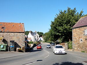
The following roads are also very important because they provide access to the center of the parish and the airport:
- Rue Des Landes
- Le Bourg
Famous People from Forest
Forest has been home to some notable individuals:
- Ernest Martin Jehan: A brave Royal Navy officer who served during World War I.
- Thomas de la Rue: He was the founder of De La Rue plc, a famous company known for printing banknotes and stamps.
- William Le Lacheur: A sea captain who had strong connections with Costa Rica.
 | Dorothy Vaughan |
 | Charles Henry Turner |
 | Hildrus Poindexter |
 | Henry Cecil McBay |


