
Saint Saviour, Guernsey facts for kids
Quick facts for kids
St. Saviour
|
||
|---|---|---|

Le Catioroc (dolmen) in Saint Saviour
|
||
|
||

Location of St. Saviour in Guernsey
|
||
| Crown Dependency | Guernsey, Channel Islands | |
| Area | ||
| • Total | 6.2 km2 (2.4 sq mi) | |
| Population
(2019)
|
||
| • Total | 2,765 | |
| • Density | 446/km2 (1,155/sq mi) | |
| Time zone | GMT | |
| • Summer (DST) | UTC+01 | |

St. Saviour is one of the ten parishes on the island of Guernsey. A parish is like a local area or district. It is located on the west coast of the island. St. Saviour is west of Castel and east of St Pierre du Bois. It is also south of Perelle Bay.
People from St. Saviour have a special nickname in Guernésiais. This is the local language of the island. They are called "fouormillaons." The postal code for this area starts with GY7.
Contents
Exploring St. Saviour: Key Features
St. Saviour has many interesting places to discover. It is home to important sites and historic buildings.
Guernsey's Water Supply
The States of Guernsey reservoir is located in St. Saviour. This large reservoir holds water for the entire island. It helps make sure everyone has enough water to drink and use.
Historic Buildings and Sites
St. Saviour is full of old and protected buildings. These places show the island's long history.
- The main church is St. Saviour Church. Outside the church, you can see the parish war memorial.
- The Chapel of St. Apolline was built in the 14th century. That's over 600 years ago!
- Fort Richmond is a Victorian-era fort. It was built a long time ago to protect the island.
- You can also find old artillery batteries at Mont Chinchon and Perelle. These were used during the Napoleonic Wars.
Ancient Stone Sites
St. Saviour has very old stone sites from the Neolithic period. This was a time when people first started farming.
- At Le Crocq, you can see two tall standing stones called menhirs. Many other stones from this site were moved long ago.
- Le Catioroc is another ancient area. It includes the Le Trepied Dolmen. A dolmen is a type of ancient stone tomb.
World War II Fortifications
During World War II, German forces occupied the Channel Islands. They built many defenses in St. Saviour.
- The St. Saviour's Tunnel complex is located under the church.
- Parts of the Batterie Mirus are also in this parish.
- You can find other German defenses too. These include anti-tank (PAK), anti-aircraft (FLAK), and machine gun positions.
Abreuvoirs: Watering Holes
St. Saviour also has "abreuvoirs." These are special places where cattle could go to drink water. They are a reminder of the island's farming past.
St. Saviour's Twin Town
St. Saviour has a special connection with a town in France. This is called a "twin town" relationship. It helps people from both places learn about each other's cultures.
- St. Saviour is twinned with Montebourg in Normandy, France.
-
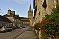
Montebourg - L'église Saint-Jacques.jpg Montebourg - L'église Saint-Jacques, a church in St. Saviour's twin town.
-

Montebourg, Jumelage, Saint Saviour, Guernsey.jpg The Saint Saviour Partnership Committee with people from Montebourg.


