Saint John, Antigua and Barbuda facts for kids
Quick facts for kids
Parish of Saint John
|
|
|---|---|

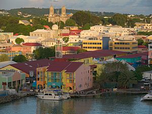
Saint John's, the capital of Saint John Parish.
|
|
 |
|
| Country | Antigua and Barbuda |
| Island | Antigua |
| Established | 11 January 1692 |
| Capital | St. John's |
| Area | |
| • Total | 74 km2 (28.5 sq mi) |
| Population
(2018 estimate)
|
|
| • Total | 56,736 |
| • Density | 768.6/km2 (1,991/sq mi) |
| Demonym(s) | Saint Johnstonian |
| Time zone | UTC-4 (AST) |
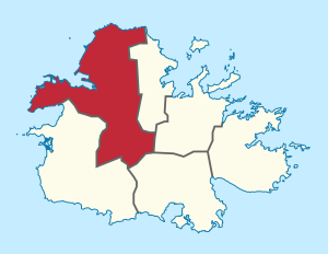
Saint John is a special area, like a county, in the country of Antigua and Barbuda. It is found on the island of Antigua. This parish is the most populated part of Antigua and Barbuda. In 2011, about 51,737 people lived there, and by 2018, the number grew to an estimated 56,736.
Most of the people in Saint John Parish live in the country's capital city, St. John's. This makes it a very important and busy area.
The northernmost tip of Antigua, called Boon Point, is located within Saint John. In 1872, the parish also took control of a small island called Redonda. Saint John Parish is also known as District "A" for administrative purposes.
Towns and Villages
Saint John Parish is home to the nation's biggest city, St. John's. Many other towns and villages are also part of this parish. Here are some of them:
- Aberdeen - 17°04′12″N 61°48′35″W / 17.06994°N 61.80977°W
- Adelin
- Barrymore
- Branns Hamlet - 17°06′13″N 61°50′10″W / 17.10366°N 61.83612°W
- Belmont - 17°05′59″N 61°49′34″W / 17.09964°N 61.82612°W
- Bellevue Heights - 17°05′32″N 61°49′23″W / 17.0922°N 61.82302°W
- Belvedere - 17°04′04″N 61°50′19″W / 17.06772°N 61.83867°W
- Bendals - 17°04′05″N 61°50′10″W / 17.06807°N 61.83604°W
- Black Rock - 17°10′09″N 61°49′39″W / 17.16912°N 61.82741°W
- Blue Waters
- Boon House - 17°10′00″N 61°50′00″W / 17.16667°N 61.83333°W
- Buckleys - 17°04′20″N 61°48′48″W / 17.07221°N 61.81337°W
- Cedar Grove - 17°09′44″N 61°49′04″W / 17.16225°N 61.8178°W
- Cedar Valley - 17°08′00″N 61°48′00″W / 17.13333°N 61.8°W
- Clare Hall - 17°07′00″N 61°49′00″W / 17.11667°N 61.81667°W
- Clarkes Hill
- Cooks Hill
- Cooks New Extension
- Crosbies - 17°09′56″N 61°49′25″W / 17.16569°N 61.82367°W
- Deanery
- Emanuel - 17°04′20″N 61°50′14″W / 17.07217°N 61.83731°W
- Five Islands - 17°07′10″N 61°53′02″W / 17.11944°N 61.88388°W
- Friars Hill - 17°08′47″N 61°50′03″W / 17.14634°N 61.83406°W
- Gambles
- Gamble's Terrace
- Golden Grove - 17°05′21″N 61°50′49″W / 17.08903°N 61.84685°W
- Gray Hill
- Grays Farm
- Green Bay - 17°06′53″N 61°50′56″W / 17.11468°N 61.84892°W
- Green Castle
- Hamiltons - 17°03′00″N 61°50′00″W / 17.05°N 61.83333°W
- Hattons - 17°07′00″N 61°51′11″W / 17.11654°N 61.85302°W
- Herberts - 17°05′38″N 61°48′51″W / 17.094°N 61.81403°W
- Hodges Bay
- Jacks Hill, Antigua and Barbuda
- Marble Hill
- Martin Hill - 17°04′22″N 61°49′01″W / 17.07291°N 61.81704°W
- McKinnon’s
- Montclear
- Nut Grove
- Obeez
- Old Battery
- Olivers - 17°04′38″N 61°48′56″W / 17.07713°N 61.81551°W
- Ottos
- Paradise View - 17°08′58″N 61°50′30″W / 17.14953°N 61.84161°W
- Piggott's Ville
- Potters Buff - 17°06′13″N 61°48′47″W / 17.10366°N 61.81297°W
- Potters Village - 17°06′48″N 61°49′11″W / 17.11337°N 61.81962°W
- Prison Farm
- Radio Range
- Renfrew - 17°05′25″N 61°48′39″W / 17.09023°N 61.81071°W
- Side Hill - 17°07′05″N 61°51′45″W / 17.11817°N 61.86245°W
- Skerrits
- St. Claire
- St. Luke - 17°04′44″N 61°50′04″W / 17.07877°N 61.83437°W
- Soldier - 17°10′07″N 61°50′10″W / 17.16859°N 61.83619°W
- Sutherlands - 17°06′45″N 61°52′48″W / 17.11241°N 61.88007°W
- Sutherlands Development - 17°07′22″N 61°49′46″W / 17.12268°N 61.8295°W
- Tomlinson - 17°06′48″N 61°48′29″W / 17.11327°N 61.80808°W
- Union Road
- Upper Gamble's
- Villa
- Weatherhills - 17°09′55″N 61°50′07″W / 17.16514°N 61.83534°W
- Woods - 17°08′07″N 61°49′33″W / 17.13526°N 61.82585°W
- Yeptons - 17°07′30″N 61°52′20″W / 17.12493°N 61.87235°W
- Yorks
Education in Saint John
Saint John Parish is home to Island Academy International. This is the only international school in the country. It is located in the town of Buckleys, which is part of Saint John Parish. It used to be known as Oliver's Estate Island Academy.
See also
 In Spanish: Parroquia de Saint John (Antigua y Barbuda) para niños
 | John T. Biggers |
 | Thomas Blackshear |
 | Mark Bradford |
 | Beverly Buchanan |

