Salamat facts for kids
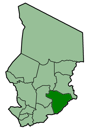
Salamat was a special area, like a big county, in the country of Chad. It was one of 14 such areas called prefectures. The main city and capital of Salamat was Am Timan. In 2002, Chad changed how it was organized. Instead of prefectures, it now has larger areas called regions.
Contents
What Was Salamat?
Salamat was a large administrative area in the southeastern part of Chad. It was known for its wide-open spaces and unique natural features. Before 2002, Chad used a system of prefectures to manage its different parts. Each prefecture had its own capital city, which was the center for government and local activities.
Where Was Salamat Located?
Salamat was in the southeastern part of Chad, a country in central Africa. It shared borders with other prefectures and even with another country, the Central African Republic. The land in Salamat was mostly flat, with some areas of savanna, which is like a grassland with scattered trees.
What is a Prefecture?
Think of a prefecture like a big district or a state within a country. It's a way for a country to divide itself into smaller parts so it can be governed more easily. Each prefecture had its own local government that helped manage things like schools, roads, and local services for the people living there.
Nature and Wildlife in Salamat
The area where Salamat was located is home to a variety of plants and animals. The climate in this part of Chad is generally hot, with a rainy season and a dry season. This weather pattern helps different types of plants and animals to thrive.
Animals of the Region
The savannas and wetlands in and around the former Salamat prefecture are home to many interesting animals. You might find large mammals like antelopes, which are graceful, deer-like creatures. There are also many types of birds, especially near water sources. Sometimes, you could even spot larger animals like elephants or giraffes, though their numbers vary.
Plant Life and Ecosystems
The plant life in Salamat was typical of the Sahel and Sudanian savanna regions. This means you would see lots of grasses, especially after the rainy season. There are also acacia trees and other types of trees that can survive in dry conditions. These plants provide food and shelter for the animals that live there, creating a balanced ecosystem.
Am Timan: The Capital City
Am Timan was the capital city of Salamat. It was the most important town in the prefecture, serving as the center for trade, education, and local government. People from the surrounding areas would come to Am Timan for markets, to get supplies, or to access services.
Life in Am Timan
Am Timan is a bustling town, even today. It has local markets where people buy and sell goods, from food to crafts. There are schools for children and health clinics. The city serves as a hub for the people living in the wider region, connecting them to the rest of Chad.
Chad's Administrative Changes
In 2002, Chad decided to change its administrative system. Instead of 14 prefectures, the country was reorganized into 22 larger areas called regions. This change was made to help improve how the country was governed and to make local administration more efficient.
Why Did Chad Change?
Governments sometimes reorganize their administrative divisions to better serve their people. This can happen for many reasons, such as to improve services, manage resources better, or adapt to changes in population. Chad's shift from prefectures to regions was part of an effort to modernize its governance.
|
|||
|
Batha · Biltine · Borkou-Ennedi-Tibesti · Chari-Baguirmi · Guéra · Kanem · Lac · Logone Occidental · Logone Oriental · Mayo-Kébbi · Moyen-Chari · Ouaddaï · Salamat · Tandjilé · |
|||
|
See also : Regions of Chad - Departments of Chad |
 | Charles R. Drew |
 | Benjamin Banneker |
 | Jane C. Wright |
 | Roger Arliner Young |


