Saline River (Little River tributary) facts for kids
Quick facts for kids Saline River |
|
|---|---|

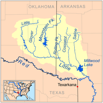
Map of the Little River watershed showing the Saline River
|
|
| Country | United States |
| State | Arkansas |
| Physical characteristics | |
| Main source | Ouachita Mountains 259 feet (79 m) 34°23′01″N 93°59′48″W / 34.38372°N 93.99659°W |
| River mouth | Millwood Lake, Little River 33°43′54″N 93°58′06″W / 33.73179°N 93.96824°W |
| Length | 80 miles (130 km) |
The Saline River is a river in southwestern Arkansas, United States. It is about 80 miles (129 km) long. The Saline River is a tributary of the Little River. A tributary is a smaller river or stream that flows into a larger one.
The Saline River is part of a larger watershed. A watershed is an area of land where all the water drains into a single river or lake. The water from the Saline River eventually flows into the Red River and then into the mighty Mississippi River.
About the Saline River
The Saline River starts in the Ouachita Mountains. These mountains are located in southeastern Polk County. The river begins its journey inside the Ouachita National Forest.
River's Journey
From its start, the Saline River generally flows south. It travels through Howard County. It also forms part of the border between Howard County and Sevier County.
As it flows, the river passes through Dierks Lake. This lake was created by a dam. The U.S. Army Corps of Engineers built this dam. They are a group that helps manage rivers and build important water projects.
Where the River Ends
The Saline River eventually joins the Little River. It does this as part of Millwood Lake. Millwood Lake is another large lake formed by a dam. This dam was also built by the U.S. Army Corps of Engineers on the Little River.
 | Emma Amos |
 | Edward Mitchell Bannister |
 | Larry D. Alexander |
 | Ernie Barnes |

