
Salmo River facts for kids
Quick facts for kids Salmo River |
|
|---|---|

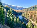
Salmo River at Ymir, British Columbia
|
|
| Country | Canada |
| Province | British Columbia |
| Physical characteristics | |
| Main source | South of Nelson |
| River mouth | Pend Oreille River 49°2′N 117°23′W / 49.033°N 117.383°W |
| Basin features | |
| Basin size | 1,300 km2 (500 sq mi) |
The Salmo River is a cool river in British Columbia, Canada. It's like a smaller stream that flows into a bigger river called the Pend Oreille River. Think of it as a helper river! The Pend Oreille River then flows into the huge Columbia River. So, the Salmo River is part of the big Columbia River family.
The area of land that collects all the water for the Salmo River is called its drainage basin. This basin is about 1,300 square kilometres (500 sq mi) big. The river's average flow, or discharge, is about 32.5 cubic metres per second (1,150 cu ft/s) each year. This means a lot of water moves through it!
Journey of the Salmo River
The Salmo River starts high up in the mountains. These mountains are located south of a town called Nelson. From there, the river flows mostly south.
It passes by the town of Salmo, British Columbia. Finally, the Salmo River joins up with the Pend d'Oreille River. This meeting point is just north of the border between Canada and the United States.
Images for kids
-
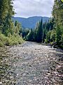
Salmo River in Ymir, British Columbia, looking south.
-
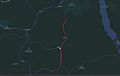
Course of the Salmo River highlighted in red.
-
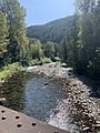
Salmo River at Hall
-
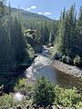
Erie Creek near Salmo
-
Salmo River north of it’s confluence with the Pend d’Oreille River


