
Salt River (Missouri) facts for kids
Quick facts for kids Salt River |
|
|---|---|
 |
|

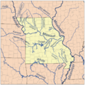
Map showing major rivers in the state of Missouri. The Salt River is at the upper right near the Mississippi River.
|
|
| Country | United States |
| State | Missouri |
| Physical characteristics | |
| Main source | Mark Twain Lake Florida, Monroe County 607 ft (185 m) 39°30′07″N 91°46′51″W / 39.50194°N 91.78083°W |
| River mouth | Mississippi River Louisiana, Pike County 449 ft (137 m) 39°28′00″N 91°03′48″W / 39.46667°N 91.06333°W |
| Length | 55 mi (89 km) |
| Basin features | |
| Basin size | 2,518 sq mi (6,520 km2) |
The Salt River is a river in eastern Missouri, United States. It flows into the mighty Mississippi River. The Salt River is about 55 miles (89 km) long. It helps drain water from an area of 2,518 sq mi (6,520 km2), which covers parts of twelve counties in Missouri.
Contents
Where Does the Salt River Start?
The Salt River begins where three smaller streams meet. These streams are called the North, Middle, and South Forks. They all come together in Monroe County.
Mark Twain Lake and the River's Path
Since 1983, a large part of the Salt River has been held back by a structure called the Clarence Cannon Dam. This dam created Mark Twain Lake, which covers the first 15 miles of the river after the forks meet.
After flowing out from the dam, the river travels generally east for about 63 miles. It moves through a quiet valley with low hills on each side. Near a town called New London, two more streams, Spencer Creek and Peno Creek, join the Salt River.
Finally, the Salt River flows into the Mississippi River. This happens at the Ted Shanks Wildlife Conservation Area, close to Louisiana in Pike County.
The Salt River's History and Name
Long ago, Native Americans lived along this river. They called it "Ohaha." Later, in a special agreement from 1804 called the Treaty of St. Louis, it was known as "the river Jeffreon."
A very famous American writer, Mark Twain, was born in 1835 in a town called Florida. This town is located right on the Salt River.
How Much Water Flows in the Salt River's Branches?
The Salt River is fed by several important branches, or forks. Here's how much water flows in some of them:
| River Branch | Location | Water Flow (cubic feet per second) |
|---|---|---|
| North Fork Salt River | Shelbina | 255 |
| Elk Fork Salt River | Paris | 202 |
| Middle Fork Salt River | Paris | 457 |
| South Fork Salt River | Santa Fe | 313 |
Images for kids
-
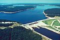
The Clarence Cannon Dam, which created Mark Twain Lake on the Salt River.
-
A map showing the major rivers in Missouri, with the Salt River highlighted.
