Samba, Jammu and Kashmir facts for kids
Quick facts for kids
Samba
|
|
|---|---|

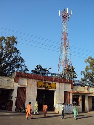
View of Samba railway station in Samba, J&K, India
|
|

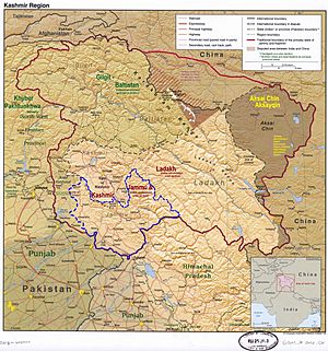
Samba lies in the Jammu division (neon blue) of the Indian-administered Jammu and Kashmir (shaded tan).
|
|
| Administering Country | India |
| Union Territory | Jammu & Kashmir |
| District | Samba |
| Named for | Sambyal Clan |
| Government | |
| • Type | Municipal Committee |
| • Body | Samba Municipal Committee |
| Area | |
| • Total | 1.65 km2 (0.64 sq mi) |
| Elevation | 384 m (1,260 ft) |
| Population
(2011)
|
|
| • Total | 12,700 |
| • Density | 7,700/km2 (19,940/sq mi) |
| Demonym(s) | Sambaite |
| Languages | |
| • Official | Dogri, Hindi, Urdu, English |
| Time zone | UTC+5:30 (IST) |
| PIN |
184121
|
| Website | http://samba.nic.in/ |
Samba is a town and a municipal committee in India. It is the main administrative center for the Samba district. Samba is located in the Indian-controlled Jammu and Kashmir region. The town has its own railway station, Samba railway station, which is part of the Jammu-Delhi railway line.
Contents
About Samba
Where is Samba Located?
Samba is found at coordinates 32.57° N and 75.12° E. It sits about 384 meters (1,260 feet) above sea level. The town is in the Shivalik Hills, next to National Highway 1-A. It is also on the banks of the Basantar River. Samba is about 40 kilometers (25 miles) away from the city of Jammu.
Samba's Neighbors
Samba District shares its borders with several other areas. To the north, it has Udhampur District. Kathua District is to the east. To the west, you'll find the Jammu and Bishnah areas of Jammu District. The International Border with Pakistan is to the south.
People of Samba
Population and Households
Religion in Samba City (2011) Hinduism (95.54%) Christianity (2.08%) Sikhism ({{{value3}}}%) Other / Not stated (0.15%)
In 2011, a report by Census India showed that Samba had 12,700 people. About 55% of them were males, and 45% were females. There were 1,365 children under seven years old. This made up about 10.75% of the total population. The town had 2,566 households.
Different Groups in Samba
Most people in Samba, about 71%, are from the general caste. About 28.57% are from scheduled castes. A very small number, 0.04%, are from scheduled tribes.
| Total | General | Schedule Caste | Schedule Tribe | Children | |
|---|---|---|---|---|---|
| Total | 12,700 | 9066 | 3629 | 5 | 1365 |
| Male | 6979 | 5041 | 1934 | 4 | 756 |
| Female | 5721 | 4025 | 1695 | 1 | 609 |
Religions in Samba
Hinduism is the main religion in Samba. Other religions like Christianity, Islam, and Sikhism are also present.
| Total | Hindu | Muslim | Christian | Sikh | Buddhist | Jain | Others | Not Stated | |
|---|---|---|---|---|---|---|---|---|---|
| Total (percentages) | 100% | 95.54% | 0.47% | 2.08% | 1.76% | 0.07% | 0.00% | 0.00% | 0.08% |
| Total (population) | 12,700 | 12,134 | 60 | 264 | 223 | 9 | 0 | 0 | 10 |
| Male | 6979 | 6644 | 42 | 128 | 156 | 4 | 0 | 0 | 5 |
| Female | 5721 | 5490 | 18 | 136 | 67 | 5 | 0 | 0 | 5 |
How Samba's Population Changed
From 2001 to 2011, Samba's population went down by 20.2%. In 2001, there were about 16,000 people. The number of females decreased by 8.1%. The number of males decreased even more, by 28%. The general caste population also went down by 27.9%. However, the scheduled caste population grew by 8.5%. The number of children decreased by 24.7% during this time.
Work and Jobs in Samba
About 34% of Samba's population, or 4,356 people, are involved in work or business. Most workers, 91.80%, have full-time jobs. The remaining 8.20% work part-time. There are 3,885 male workers and 471 female workers.
Famous Places in Samba
Mansar Lake
Mansar Lake is a beautiful lake located about 22 kilometers (14 miles) from Samba. It is surrounded by hills and several Hindu temples. Many tourists and religious visitors come to this lake. There are also tourist huts and rooms by the lake for visitors to stay. The government has a special group to help develop tourism in this area.
Villages and Temples
Purmandal is a village about 39 kilometers (24 miles) from Jammu. You can reach it from Samba by road. Purmandal is sometimes called "Chotta Kashi" because it has old Shiva temples. These temples are very important for religious reasons and are surrounded by the Shivalik Hills.
Another village called Utterbani is near Purmandal, about 5 kilometers (3 miles) away. It is on the bank of the Devika River and also has historic temples.
The Chichi Mata Mandir is a famous temple located within Samba itself. It is believed to be one of the shaktipeeths, where a part of Goddess Sati's body fell. This temple is only 2 kilometers (1.2 miles) from Samba town on the National Highway. Many tourists and pilgrims visit it all year round.
Learning in Samba
Samba has several colleges and institutes for higher education. These include:
- Bhargava Law College
- Central University of Jammu
- Pandit Prem Nath Dogra Government Degree College Samba
- Government Degree College (Vijaypur, Ramgarh, Purmandal, Ghagwal)
- Bhargava Degree College
- Bhargava College Of Engineering And Technology
- Dogra Degree College
- Dogra Law College
- RK Degree College
Getting Around Samba
By Air
The closest airport to Samba is Jammu Airport. It is about 31 kilometers (19 miles) away in Jammu.
By Rail
You can reach Samba by train from many major cities in India. The main railway station is Samba railway station (SMBX).
By Bus
Samba is located on National Highway 44 (which used to be NH-1A). This means there are regular buses that connect Samba to other parts of the country.
See also
 In Spanish: Samba (India) para niños
 | John T. Biggers |
 | Thomas Blackshear |
 | Mark Bradford |
 | Beverly Buchanan |


