San Isidro, Culebra, Puerto Rico facts for kids
This article is about San Isidro (disambiguation)|San Isidro. For other uses, see San Isidro, Culebra, Puerto Rico (disambiguation).
Quick facts for kids
San Isidro
|
|
|---|---|
|
Barrio
|
|

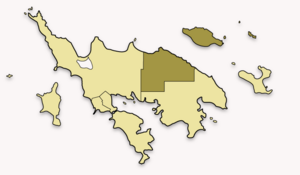
Map of Culebra highlighting San Isidro
|
|
| Commonwealth | |
| Municipality | |
| Area | |
| • Total | 25.62 sq mi (66.4 km2) |
| • Land | 2.26 sq mi (5.9 km2) |
| • Water | 23.36 sq mi (60.5 km2) |
| Elevation | 0 ft (0 m) |
| Population
(2010)
|
|
| • Total | 16 |
| • Density | 7.1/sq mi (2.7/km2) |
| Source: 2010 Census | |
| Time zone | UTC−4 (AST) |
| ZIP Code |
00775
|
San Isidro is a small area, known as a barrio, located on the island of Culebra, Puerto Rico. Culebra is a special island that is also its own municipality in Puerto Rico. In 2010, only 16 people lived in San Isidro, making it a very quiet place.
This barrio is unique because it includes not only a part of the main Culebra island in the northeast but also several smaller islands and islets nearby. These include interesting spots like Roca Speck, Cayo Norte, Cayo Sombrerito, Cayos Geniquí, Cayo Tiburón, and Cayo Ballena.
Population Over Time
The number of people living in San Isidro has changed quite a bit over the years. Here's a look at how its population has grown and shrunk:
| Historical population | |||
|---|---|---|---|
| Census | Pop. | %± | |
| 1930 | 116 | — | |
| 1940 | 75 | −35.3% | |
| 1950 | 37 | −50.7% | |
| 1980 | 8 | — | |
| 1990 | 18 | 125.0% | |
| 2000 | 22 | 22.2% | |
| 2010 | 16 | −27.3% | |
| U.S. Decennial Census 1899 (shown as 1900) 1910-1930 1930-1950 1980-2000 2010 |
|||
More to Explore
- List of communities in Puerto Rico
- List of barrios and sectors of Culebra, Puerto Rico
See also
 In Spanish: San Isidro (Culebra) para niños
Black History Month on Kiddle
African-American Labor Activists
 | William Lucy |
 | Charles Hayes |
 | Cleveland Robinson |

All content from Kiddle encyclopedia articles (including the article images and facts) can be freely used under Attribution-ShareAlike license, unless stated otherwise. Cite this article:
San Isidro, Culebra, Puerto Rico Facts for Kids. Kiddle Encyclopedia.

