San Lucas Tolimán facts for kids
Quick facts for kids
San Lucas Tolimán
|
|
|---|---|
|
Municipality of Guatemala
|
|

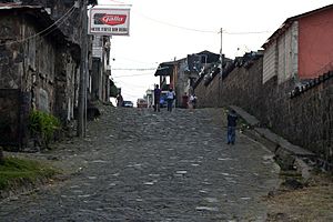
Street of San Lucas Tolimán
|
|
| Country | |
| Department | |
| Catholic mission built | 1584 |
| Government | |
| • Type | municipal |
| Elevation | 1,700 m (5,600 ft) |
| Highest elevation | 3,144 m (10,315 ft) |
| Lowest elevation | 1,562 m (5,125 ft) |
| Population
(census 2002)
|
|
| • Municipality of Guatemala | 21,455 |
| • Urban | 12,674 |
| Time zone | UTC-6 (Central Time) |
| Country calling code | 502 |
| Climate | Aw |
| Website | www.inforpressca.com/sltoliman |
San Lucas Tolimán is a town in Guatemala. It is located in the Sololá Department, which is like a state or province. The town sits on the southeastern shore of Lago de Atitlán, a beautiful lake.
About 17,000 people live in the town itself. Most of the people, around 90–95%, are from the Highland Maya group. Many more people live in the villages around the town.
San Lucas Tolimán is about 1,700 meters (5,577 feet) above sea level. This high altitude gives the town a pleasant climate, often called "eternal spring." Temperatures usually range from 10 to 27 degrees Celsius (50 to 80 degrees Fahrenheit) all year.
The dry season, or "summer," lasts from November to June or July. The rainy season, or "winter," covers the other six months. Because it's so high up, there are no malaria problems here. The land around San Lucas Tolimán goes from 1,562 meters (5,125 feet) at the lake's edge up to 3,144 meters (10,315 feet) at the top of Volcán Tolimán. This volcano is just west of the town.
Contents
History of San Lucas Tolimán
Early Spanish Influence
After the Spanish arrived in Guatemala, San Lucas Tolimán became part of a large area called "Tecpán Atitlán." In 1730, it became an important part of this region. The Roman Catholic Church played a big role here. Franciscans, a group of priests, were in charge of teaching the Catholic faith. They had many churches and schools in the area.
In 1586, a friar named Alonso Ponce described San Lucas Tolimán as a "little town." The Franciscans taught children aged 6 and older. Girls had classes in the afternoon, and boys had them at sunset. These classes lasted two hours and focused on learning church teachings and prayers. Older local people, called "fiscales," or priests led these lessons. Adults went to Mass every Sunday and on holidays. After Mass, they also received religious teachings in their own language.
After Guatemala's Independence
Guatemala became independent from Spain. On September 2, 1877, San Lucas Tolimán officially became a municipality. This happened during the time when General Justo Rufino Barrios was in charge.
The San Lucas Mission in the 1900s
San Lucas Tolimán is well known for the San Lucas Tolimán Mission. This mission was started by the Roman Catholic Diocese of New Ulm from Minnesota, USA. It began in the 1960s thanks to Monsignor Gregory Thomas Schaffer.
Monsignor Schaffer started many helpful projects. These included programs for education, health, and farming. He helped give land to 4,000 families. He also set up medical clinics and started a fair-price coffee project. This project helped coffee farmers get a good price for their crops.
Katie Wallyn, a Catholic missionary from Minnesota, has also helped the community. Her foundation, L.E.A.S.T, supports elderly people. Monsignor Schaffer also encouraged volunteers to create Agua del Pueblo (AdP). AdP is one of the oldest non-profit groups in the world focused on providing clean water and sanitation. After Monsignor Schaffer passed away, a new group called "Friends of San Lucas" continued his important work in the area.
Recent Times
In 2015, the mayor of San Lucas Tolimán was Oscar Pic Solís. He had been mayor since 2007. Moisés Miza Castro is the current mayor.
Areas of San Lucas Tolimán
San Lucas Tolimán covers an area of 116 square kilometers. It is divided into different parts, including the main town, villages, and rural settlements.
| Category | As of 1985 | As of 1994 |
|---|---|---|
| Municipal capital | San Lucas Tolimán | |
| Villages |
|
Panimaquip |
| Rural settlements | Tzlamabaj |
|
| Micro sections |
|
N/A |
| Residential neighborhoods | N/A |
|
Climate
San Lucas Tolimán has a tropical climate. This means it is generally warm all year round.
| Climate data for San Lucas Tolimán | |||||||||||||
|---|---|---|---|---|---|---|---|---|---|---|---|---|---|
| Month | Jan | Feb | Mar | Apr | May | Jun | Jul | Aug | Sep | Oct | Nov | Dec | Year |
| Mean daily maximum °C (°F) | 25.5 (77.9) |
25.4 (77.7) |
26.3 (79.3) |
25.7 (78.3) |
25.3 (77.5) |
23.3 (73.9) |
24.4 (75.9) |
24.3 (75.7) |
23.7 (74.7) |
24.0 (75.2) |
24.9 (76.8) |
24.9 (76.8) |
24.8 (76.6) |
| Daily mean °C (°F) | 18.8 (65.8) |
18.6 (65.5) |
19.5 (67.1) |
19.6 (67.3) |
19.6 (67.3) |
18.9 (66.0) |
19.3 (66.7) |
19.0 (66.2) |
18.7 (65.7) |
18.8 (65.8) |
18.8 (65.8) |
18.3 (64.9) |
19.0 (66.2) |
| Mean daily minimum °C (°F) | 12.2 (54.0) |
11.9 (53.4) |
12.8 (55.0) |
13.5 (56.3) |
14.0 (57.2) |
14.5 (58.1) |
14.2 (57.6) |
13.8 (56.8) |
13.8 (56.8) |
13.6 (56.5) |
12.8 (55.0) |
11.8 (53.2) |
13.2 (55.8) |
| Average precipitation mm (inches) | 3 (0.1) |
18 (0.7) |
16 (0.6) |
51 (2.0) |
144 (5.7) |
387 (15.2) |
209 (8.2) |
220 (8.7) |
388 (15.3) |
214 (8.4) |
44 (1.7) |
10 (0.4) |
1,704 (67) |
| Source: Climate-Data.org | |||||||||||||
Where is San Lucas Tolimán?
San Lucas Tolimán is located 42 kilometers (about 26 miles) south of Sololá, Sololá, which is the capital city of the department.
 |
San Antonio Palopó and Lake Atitlán, in Sololá Department |  |
||
| Santiago Atitlán, Sololá Department municipality | Pochuta and Patzún, Chimaltenango Department municipality | |||
| Patulul, Suchitepéquez Department municipality |
See also
 In Spanish: San Lucas Tolimán para niños
 | William M. Jackson |
 | Juan E. Gilbert |
 | Neil deGrasse Tyson |


