San Ramón, Uruguay facts for kids
Quick facts for kids
San Ramón
|
|
|---|---|
|
City & Municipality
|
|

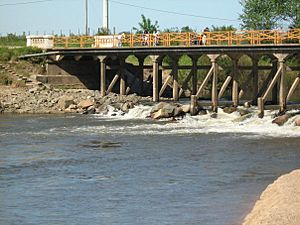
Santa Lucía River at San Ramón
|
|
| Country | |
| Department | |
| Founded | 1867 |
| Elevation | 50 m (160 ft) |
| Population
(2011 Census)
|
|
| • Total | 7,133 |
| Time zone | UTC -3 |
| Postal code |
90600
|
| Dial plan | +598 4312 (+4 digits) |
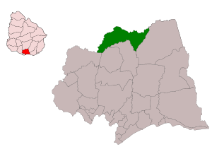
San Ramón is a small city located in the northern part of the Canelones Department in southern Uruguay. The city is also the center of a larger area called the San Ramón municipality.
Contents
Exploring San Ramón's Location
San Ramón is found on the south side of the Santa Lucía River. This river forms the border with the Florida Department. South of the city is a hill called Cuchilla del Chamizo. A small stream, Arroyo Pilatos, flows about 3 kilometers south of the city.
How to Get to San Ramón
The city sits where three roads meet: Route 6, Route 12, and Route 63. It's about 79 kilometers north of Montevideo, the capital city of Uruguay. Montevideo's center is considered "Kilometre Zero."
San Ramón is also about 7.5 kilometers south of a village called Chamizo. This village is in the Florida Department. The town of Tala is about 16 kilometers to the east-southeast. A railroad track also runs through San Ramón. This track connects Montevideo to cities like Melo and Río Branco, which is near the border with Brazil.
A Look at San Ramón's History
San Ramón started as a small village in 1867. Over time, it grew bigger and more important.
- On July 11, 1910, it was officially recognized as a "Villa," which means a town. This change happened because of a law called Ley Nº 3.643.
- Later, on June 26, 1953, San Ramón became a "Ciudad," or city. This was made official by another law, Ley Nº 11.952.
San Ramón's Population
In 2011, a census showed that 7,133 people lived in San Ramón. The local government, called the Intendencia de Canelones, estimated the population of the whole municipality to be 8,123 people in 2010.
Here's how the population of San Ramón has changed over the years:
| Year | Population |
|---|---|
| 1908 | 4,956 |
| 1963 | 5,668 |
| 1975 | 6,594 |
| 1985 | 7,001 |
| 1996 | 6,828 |
| 2004 | 6,992 |
| 2011 | 7,133 |
This information comes from the Instituto Nacional de Estadística de Uruguay, which is Uruguay's national statistics office.
Places to Worship
- St. Raymond Nonnatus Parish Church is a Roman Catholic church located in San Ramón.
See also
 In Spanish: San Ramón (Uruguay) para niños
 | Delilah Pierce |
 | Gordon Parks |
 | Augusta Savage |
 | Charles Ethan Porter |


