Sandy Island, New Caledonia facts for kids
Sandy Island (also called Île de Sable in French) is a "phantom island." This means it was shown on maps for a long time, but it doesn't actually exist! For over 100 years, maps showed it near New Caledonia, a French territory in the Pacific Ocean.
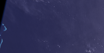
The island was on many maps and sea maps starting in the late 1800s. But it was removed from French sea maps in 1974. Sandy Island became famous in November 2012. An Australian research ship, the R/V Southern Surveyor, sailed right through where the island was supposed to be. They "undiscovered" it because there was no island there! After that, many maps, including Google Maps, quickly took Sandy Island off.
History of a Mistake
In 1774, Captain James Cook drew a "Sandy I." on his map. It was near New Caledonia. This drawing was part of the real reef around New Caledonia. Cook's map was pretty accurate, usually within 20 miles.
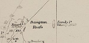
Later, in 1876, a whaling ship named Velocity reported seeing an island. This report led to the fake island appearing on maps from the late 1800s. The ship's captain said he saw "heavy breakers" (big waves) and "Sandy Islets" (small sandy islands). These sightings were then added to an Australian sea guide in 1879. It said the sandy islets were between 19°7'S and 19°20'S latitude. Before this, the closest land was the Chesterfield Islands, about 100 kilometers (62 miles) to the west. Back then, mapmakers would list anything that might be a danger to ships, just to be safe.
It's not clear if the fake Sandy Island was meant to correct Cook's earlier map. Cook's "Sandy I." was hundreds of miles further east. The fake Sandy Island was usually shown around 160°E longitude. This was after new tools like the marine chronometer made it easier to figure out exact longitude.
Over time, sea maps started putting "ED" next to Sandy Island. "ED" means "existence doubtful." This was because people kept trying to find the island but couldn't. Scientists later used special equipment to map the ocean floor. They found that the water where Sandy Island was supposed to be was very deep. It was between 1,488 and 2,353 meters (4,882 to 7,720 feet) deep. There was no island or shallow reef.
Because no island was found, the French Hydrographic Service removed Sandy Island from their official maps in 1974. The Australian Hydrographic Service did the same in 1985. This information was shared with other map services around the world. But Sandy Island still appeared in many digital maps used by scientists. This happened because it was in a database called the World Vector Shoreline Database (WVS). This database was made when paper maps were turned into digital ones. Sometimes, mistakes from the original maps or human errors in digitizing them got carried over.
Floating Rocks Mistake
The ship Velocity might have seen floating pumice rocks in 1876. Pumice is a light, bubbly rock that comes from underwater volcanoes. Large groups of these rocks, called pumice sea rafts, can float on the ocean. They might have looked like an island.
A study in 2004 found that pumice rafts from a volcano near Tonga traveled over 3,000 kilometers (1,864 miles). The study showed that these rafts passed very close to where Sandy Island was mapped. This happened about 200 days after the volcano erupted. Winds and ocean currents in the area can push these pumice rafts between Fiji and New Caledonia, on their way to Australia. This makes the idea of floating rocks a good explanation for the mistake.
The "Undiscovery"
As mentioned, the French Naval and Oceanographic Service removed the island from their maps in 1974. Some amateur radio fans also said the island didn't exist in 2000. They noticed it was on some maps but not others.
The "undiscovery" became big news on November 22, 2012. Australian scientists on the R/V Southern Surveyor were studying plate tectonics (how Earth's crust moves) in the area. They noticed that different maps showed different things. So, they decided to sail to the spot where Sandy Island was supposed to be. The crew found no island at all. The ocean floor was never shallower than 1,300 meters (4,265 feet) deep.
The missing island also became a big topic among scientists. Some were surprised that such a mistake could exist. Some digital maps even showed a small bump of land at Sandy Island's location. Other maps, made from satellite images, showed no sea surface temperatures there, which usually means land. However, it turned out that these maps used a "land mask." This is a digital filter that tells the computer what is land and what is water. Since the World Vector Shoreline Database (WVS) had the error, it spread to other maps that used this land mask. So, these maps weren't proving the island existed. They were just showing the same old mistake.
The Royal Australian Navy's mapping department said that putting a fake island on a map to catch people who copy maps (a "copyright trap") was not a normal practice for sea maps. They said the island's appearance on many maps was likely just a human error.
Sandy Island was shown on Google Maps until November 26, 2012, when it was removed. On Google Earth, the area where the island was supposed to be now looks black. On November 29, 2012, the National Geographic Society announced that they were officially taking Sandy Island off all their maps. A geographer from National Geographic said that "full evidence has finally been presented."
See also
 In Spanish: Isla Sandy (Nueva Caledonia) para niños


