Sanriku facts for kids
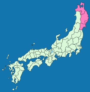
Sanriku (三陸) is a special area in Japan. It is located on the northeastern coast of Honshu, which is Japan's largest island. Sanriku includes parts of Aomori, Iwate, and Miyagi Prefecture. Sometimes, people called this region Rikushū (陸州).
The Sanriku coast has a very interesting shape. It has many small bays, about 36 of them. These bays are shaped in a way that can make ocean waves much stronger when they hit the shore. This was seen during the powerful 2011 Tōhoku earthquake and tsunami, where the shape of the coast made the tsunami's impact even greater.
History of Sanriku
In 1869, some old Japanese provinces were changed. Two of these, Mutsu and Dewa, were divided into smaller parts.
The large Mutsu province was split into five new provinces. These were Rikuōku, Rikuchū, Rikuzen, Iwashiro, and Iwaki. The first three of these new provinces – Rikuōku, Rikuchū, and Rikuzen – were together known as the "Three Riku." This is where the name Sanriku comes from.
Even though these new provinces were officially ended in July 1871, the name Sanriku is still used today. It describes the beautiful Sanriku Coast, which stretches from Aomori all the way down to the Oshika Peninsula in Miyagi.
See also
 In Spanish: Sanriku para niños
 | Chris Smalls |
 | Fred Hampton |
 | Ralph Abernathy |


