
Sant'Antioco facts for kids
Quick facts for kids
Sant'Antioco
Santu Antiogu
|
||
|---|---|---|
| Comune di Sant'Antioco | ||

Seafront
|
||
|
||
| Country | Italy | |
| Region | Sardinia | |
| Province | South Sardinia | |
| Frazioni | Maladroxia | |
| Area | ||
| • Total | 115.59 km2 (44.63 sq mi) | |
| Elevation | 10 m (30 ft) | |
| Population
(2014)
|
||
| • Total | 11,423 | |
| • Density | 98.823/km2 (255.952/sq mi) | |
| Demonym(s) | Antiochensi | |
| Time zone | UTC+1 (CET) | |
| • Summer (DST) | UTC+2 (CEST) | |
| Postal code |
09017
|
|
| Dialing code | 0781 | |
| Patron saint | Saint Antiochus (Sant'Antioco) | |

Sant'Antioco is the name of both an island and a town in southwestern Sardinia, Italy. The town is also called a comune, which is like a local government area. It is part of the Province of South Sardinia.
With about 11,730 people, the town of Sant'Antioco is the biggest community on the island. This area was once home to an ancient city called Sulci. People thought Sulci was the second most important city in Sardinia long ago.
Contents
Discover the Island of Sant'Antioco

Sant'Antioco is the second largest island in the Sardinia region. Only Sardinia itself is bigger. It covers about 109 square kilometers (42 square miles). It is also the fourth largest island in all of Italy.
The island is about 87 kilometers (54 miles) from Cagliari, a major city. You can reach it easily by a modern bridge. The island is split between two towns: Sant'Antioco and Calasetta. Other small places include Maladroxia, a tourist spot, and Cussorgia.
Beaches and Coastline
The coast of Sant'Antioco island has both sandy beaches and rocky areas. Some popular beaches are Maladroxia and Coaquaddus. These are in the Sant'Antioco town area. In the Calasetta area, you can find Sotto Torre, Le Saline, and Spiaggia Grande beaches.
A Journey Through Sant'Antioco's History
_(cropped).jpg)
People have lived on the island of Sant'Antioco for a very long time. The first settlers arrived around 5,000 BC. They were part of the Ozieri culture, and they mainly fished and farmed. You can still find their ancient tombs, called domus de janas, and tall stone menhirs.
Later, the nuragic civilization lived here. They built unique stone towers. One important discovery is the Giants' grave of Su Niu de su Crobu, which means "Crow's Nest."
Ancient Cities and Empires
Around 800 BC, the Phoenicians built a new settlement called Sulky. Archeologists have found a special burial ground for children, called a tophet, from this time. Later, in the 6th century BC, the city became a colony of Carthage. Another burial ground from the Carthaginian time has been found.
The Carthaginians lost control in the 3rd century BC. Then, the Romans took over Sulky. They connected the island to the mainland with a man-made land bridge. During a Roman civil war, Sulky supported Pompey. After Julius Caesar won, the city was punished. The Romans called the island Plumbaria because of its lead mines.
The Name Sant'Antioco
The town's current name comes from Saint Antiochus. He was a Christian who taught people in the area. He was killed in 125 AD for his beliefs.
After the Roman Empire declined, Sant'Antioco became a strong fort for the Byzantine Empire. However, Saracens (pirates from North Africa) attacked the island many times from the 700s. People started leaving the island for safer places inland. The island remained important for people making pilgrimages to honor Saint Antiochus.
Repopulation and Modern Times
A new settlement was started around 935 by the local ruler of Cagliari. But this settlement was also abandoned later. The island became part of the Kingdom of Sardinia in 1324. Later, it was owned by the archbishop of Cagliari and then a religious group.
In the 1700s, people began to move back to the island. By the middle of that century, there were about 450 people living in houses, workshops, and huts.
In 1793, French soldiers took over the island for a few months. They freed the citizens from church taxes. The last attack by pirates happened in 1815. In the same year, the remains of the patron saint were brought back to the main church.
What to See in Sant'Antioco
Sant'Antioco has many interesting historical places to visit:
- The ancient Basilica of Sant'Antioco. This church was rebuilt around 1089-1102. It has catacombs underneath.
- The Roman bridge, which was repaired in medieval times.
- An old Roman fountain.
- The ancient acropolis, which was the highest part of the city.
- Phoenician and Punic burial grounds.
- A tophet, a special sacred area.
- An underground village.
- The Ferruccio Barreca Archaeological Museum, where you can see artifacts.
- The Forte Su Pisu, a fort built between 1812 and 1815.
Local Events
From May 15 to June 15 each year, a famous tuna "mattanza" takes place. This is a traditional way of fishing for Atlantic bluefin tuna.
Climate in Sant'Antioco
| Climate data for S. Antioco (1981–2010) | |||||||||||||
|---|---|---|---|---|---|---|---|---|---|---|---|---|---|
| Month | Jan | Feb | Mar | Apr | May | Jun | Jul | Aug | Sep | Oct | Nov | Dec | Year |
| Mean daily maximum °C (°F) | 15.1 (59.2) |
15.9 (60.6) |
18.3 (64.9) |
20.3 (68.5) |
24.8 (76.6) |
29.1 (84.4) |
31.9 (89.4) |
32.3 (90.1) |
28.2 (82.8) |
24.7 (76.5) |
19.5 (67.1) |
16.0 (60.8) |
23.0 (73.4) |
| Mean daily minimum °C (°F) | 7.4 (45.3) |
7.1 (44.8) |
8.9 (48.0) |
10.7 (51.3) |
14.7 (58.5) |
18.2 (64.8) |
20.9 (69.6) |
21.3 (70.3) |
18.3 (64.9) |
15.5 (59.9) |
11.6 (52.9) |
8.4 (47.1) |
13.6 (56.5) |
| Average precipitation mm (inches) | 56.2 (2.21) |
57.1 (2.25) |
42.2 (1.66) |
53.3 (2.10) |
28.6 (1.13) |
12.1 (0.48) |
0.6 (0.02) |
7.4 (0.29) |
41.9 (1.65) |
60.3 (2.37) |
83.5 (3.29) |
73.9 (2.91) |
517.1 (20.36) |
| Source: Climatologia della Sardegna per il trentennio 1981-2010 | |||||||||||||
Gallery
-
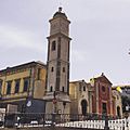
Basilica of Sant'Antioco Martire
-
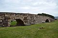
Roman bridge
-
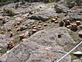
Tophet
-
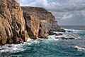
Rocky coastline

.jpg)

.jpg)
See also
 In Spanish: Sant'Antioco para niños
