Santa María de Guía de Gran Canaria facts for kids
Quick facts for kids
Santa María de Guía de Gran Canaria
|
|||
|---|---|---|---|

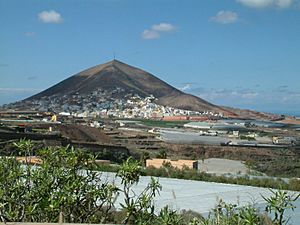
View of La Atalaya
|
|||
|
|||

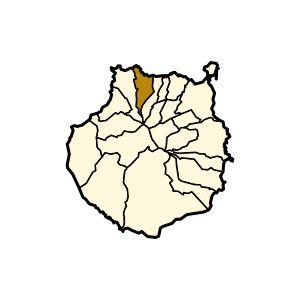
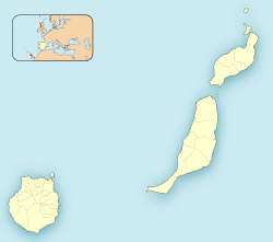
Municipal location in Gran Canaria
|
|||
| Country | Spain | ||
| Autonomous Community | Canary Islands | ||
| Province | Las Palmas | ||
| Island | Gran Canaria | ||
| Area | |||
| • Total | 42.59 km2 (16.44 sq mi) | ||
| Elevation
(AMSL)
|
180 m (590 ft) | ||
| Population
(2018)
|
|||
| • Total | 13,924 | ||
| • Density | 326.93/km2 (846.75/sq mi) | ||
| Time zone | UTC+0 (CET) | ||
| • Summer (DST) | UTC+1 (CEST (GMT +1)) | ||
| Postal code |
35450
|
||
| Area code(s) | +34 (Spain) + 928 (Las Palmas) | ||
| Website | www.santamariadeguia.es | ||
Santa María de Guía de Gran Canaria is a town and a local government area (called a municipality) in the Las Palmas province. It's part of the Canary Islands of Spain. This town is located on the north side of Gran Canaria island. In 2013, about 13,811 people lived there, and the area covers about 42.59 square kilometers.
The town of Santa María de Guía is in a valley, about 2 kilometers from the coast. It is also about 19 kilometers west of the city of Las Palmas. The municipality stretches from the coast all the way into the mountains of the island. A major road, the GC-2 motorway, runs north of the town.
Contents
What's in a Name?
The name of this municipality comes from its main town. It combines the name of an old chapel, founded in honor of Santa María de Guía in the late 1400s.
How the Name Changed Over Time
Long ago, before the year 1483, the island was home to the Guanches, who were the native people. Back then, this area was called Aguía. This name was used for the town and its surroundings, near another important aboriginal area called Agaldar. The name Aguía stayed until 1555.
After Europeans took over the Canary Islands, the town became known as Villa de Guía, or just Guía. This name was used for a long time during the colonial period, until the 1800s. In the 1800s, people started calling it Guía de Gran Canaria. This helped to tell it apart from other places with similar names, like Guía de Isora on the island of Tenerife.
In the 1900s, during the time of the Franco dictatorship, the mayor suggested changing the name to Santa María de Guía. This was to include the name of the Catholic church that had been there since the 1500s. The local government approved this change in 1963. After some discussion, the name was officially changed to Santa María de Guía de Gran Canaria by the government on July 23, 1963.
In 2008, the local government asked people living there if they wanted to go back to the name Guía de Gran Canaria.
Where is Santa María de Guía?
Santa María de Guía is located in the north of Gran Canaria. It has a triangular shape, with its point facing south, close to the caldera (a large volcanic crater) of the Pinos de Gáldar.
Borders and Coastline
To the east, it shares a border with the municipality of Moya. This border follows the Barranco de Moya (a type of ravine) all the way to the sea. To the west, the border follows some channels and goes around the Pico de La Atalaya mountain, dividing it in two.
The coastline stretches from Caleta de Arriba to the mouth of the Barranco de Moya. The coast is mostly rocky cliffs because of erosion. However, there are some exceptions, like San Felipe beach, which gets covered with sand in the summer.
Weather and Climate
The weather in Santa María de Guía depends on its location in the north. The area has three main altitude zones:
- The coastal zone, which goes up to 300 meters high.
- The middle zone, between 300 and 600 meters high.
- The high zone, which is above 600 meters.
As you go further inland and higher up the island, there are fewer sunny days each year. It also rains more, and temperatures are generally cooler.
Population
The number of people living in Santa María de Guía has changed over the years:
| Historical population | ||||||||||||||||||||||||||||
|---|---|---|---|---|---|---|---|---|---|---|---|---|---|---|---|---|---|---|---|---|---|---|---|---|---|---|---|---|
|
|
|||||||||||||||||||||||||||
Important Historical Places
Caves of Valerón
The caves of Valerón, also known as cenobio de Valerón, are a very important cultural site. They are the largest ancient storage place for grain from before the Spanish conquest. These caves show how important farming was in Gran Canaria, especially growing grains. This was unique among the Canary Islands, as most others focused more on raising animals.
Quintana House
The Quintana House is a great example of old architecture in Santa María de Guía. It is located in the main square of Guía, and its buildings date back to the 16th century. The house has a special Canarian balcony made in the Mudejar style (a mix of Christian and Islamic art). It is made of wood and has a coat of arms with the family names Guanarteme and Quintana.
See also
 In Spanish: Santa María de Guía de Gran Canaria para niños
 | May Edward Chinn |
 | Rebecca Cole |
 | Alexa Canady |
 | Dorothy Lavinia Brown |


