Santa María Chiquimula facts for kids
Quick facts for kids
Santa María Chiquimula
|
||
|---|---|---|
|
Municipality
|
||
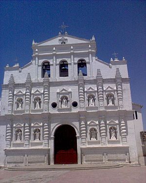
Catholic church of Santa María Chiquimula
|
||
|
||
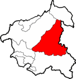
Santa María Chiquimula within Totonicapán
|
||
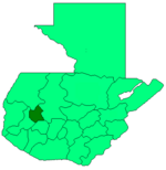
Totonicapán within Guatemala
|
||
| Country | ||
| Department | ||
| Government | ||
| • Type | Municipal | |
| Area | ||
| • Total | 236 km2 (91 sq mi) | |
| Elevation | 2,130 m (6,990 ft) | |
| Population
(2018 census)
|
||
| • Total | 55,013 | |
| • Density | 233.1/km2 (603.7/sq mi) | |
| • Ethnicities | Kʼicheʼ Ladino | |
| • Religions | Catholicism Evangelicalism Maya | |
| Climate | Cwb | |
| Website | Official site: http://munisantamariachiquimula.org | |
Santa María Chiquimula is a town and a municipality in Guatemala. It is located in the western highlands of the country. This area is part of the Totonicapán department. The town sits high up, at about 2,130 meters (about 7,000 feet) above sea level.
About Santa María Chiquimula
Santa María Chiquimula is a municipality with a total area of 236 square kilometers. In 2018, about 55,013 people lived in the whole municipality. The main town itself had a population of 15,919 people in the same year.
Languages and Culture
The people living here are mostly indigenous. Many speak the Mayan Kʼicheʼ language. However, Spanish is also widely spoken throughout the area. The culture is a mix of Kʼicheʼ traditions and modern Guatemalan life.
What They Grow
The main crops grown in this region are corn and black beans. These are very important foods for the local people. They are a big part of the area's economy and daily life.
See also
 In Spanish: Santa María Chiquimula para niños
 | James Van Der Zee |
 | Alma Thomas |
 | Ellis Wilson |
 | Margaret Taylor-Burroughs |


