Santa María de Huerta facts for kids
Quick facts for kids
Santa María de Huerta
|
||
|---|---|---|

|
||
|
||
| Country | ||
| Autonomous Community | ||
| Province | ||
| Comarca | Campo de Gómara | |
| Government | ||
| • Type | Mayor-council government | |
| • Body | Ayuntamiento de Santa María de Huerta | |
| Area | ||
| • Total | 49.15 km2 (18.98 sq mi) | |
| Elevation | 762 m (2,500 ft) | |
| Population
(2018)
|
||
| • Total | 267 | |
| • Density | 5.432/km2 (14.070/sq mi) | |
| Demonym(s) | Hortense, -sa (es) | |
| Time zone | CET (GMT +1) | |
| • Summer (DST) | CEST (GMT +2) | |
| Postcode |
42260
|
|
Santa María de Huerta is a small town, also called a municipality, in Spain. It is located in the Campo de Gómara area, which is part of the Province of Soria. This province is in the larger region of Castile and León. The town is easy to reach because it's right next to the A2 highway and close to the border with Aragon.
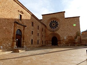
In 2004, about 419 people lived in Santa María de Huerta. By 2018, the population was around 267 people. The main attraction in the village is a very old and important Cistercian monastery of Santa María de Huerta.
Contents
About Santa María de Huerta
Santa María de Huerta is a quiet place with a rich history. It's known for its beautiful countryside and its famous monastery. The people who live here are called Hortense.
Location and Geography
The town is located in the eastern part of the Province of Soria. It sits at an elevation of 762 meters (about 2,500 feet) above sea level. The total area of the municipality is about 49.15 square kilometers. Its position near a major highway makes it accessible for visitors.
Local Government
Like many towns in Spain, Santa María de Huerta has a local government called an Ayuntamiento. This is like a town council. The head of the town is called the Mayor. As of 2015, the Mayor was Mercedes Aguilar Medina. The local government helps manage the town and its services.
The Monastery of Santa María de Huerta
The most famous landmark in Santa María de Huerta is its large Cistercian monastery. This monastery is a very old and important religious building. It was built by monks who followed the Cistercian order.
History of the Monastery
The monastery was founded a long, long time ago. Cistercian monks are known for their simple lives and their focus on prayer and hard work. They often built their monasteries in quiet, rural areas. The monastery in Santa María de Huerta is a great example of their architecture and way of life.
Architecture and Design
The monastery has impressive architecture. It includes a church, cloisters (covered walkways), and other buildings where the monks lived and worked. Many parts of the monastery show the typical style of Cistercian buildings, which is often grand but also simple and strong. Visitors can explore the different areas and imagine what life was like for the monks centuries ago.
Visiting Santa María de Huerta
Santa María de Huerta is a great place to visit if you are interested in history and old buildings. The monastery is open to the public and offers a glimpse into Spain's past. The town's quiet atmosphere also makes it a nice spot for a peaceful getaway.
See also
 In Spanish: Santa María de Huerta para niños
 | Victor J. Glover |
 | Yvonne Cagle |
 | Jeanette Epps |
 | Bernard A. Harris Jr. |


