Santa Teresa Mountains facts for kids
Quick facts for kids Santa Teresa Mountains |
|
|---|---|

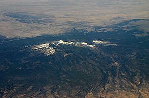
Oblique air photo of Santa Teresa Mountains, facing northwest, March 2007
("The Tablelands" and "Lone Cedar Mesa" w/forests-NW) |
|
| Highest point | |
| Peak | Mount Turnbull, San Carlos Apache Indian Reservation, Arizona |
| Elevation | 8,282 ft (2,524 m) |
| Dimensions | |
| Length | 19 mi (31 km) |
| Width | 11 mi (18 km) |
| Geography | |
| Country | United States |
| Settlement | Fort Thomas, Arizona |
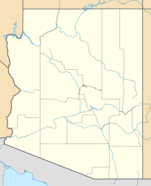
| Range coordinates | 32°58′01″N 110°17′34″W / 32.9670°N 110.2929°W |
The Santa Teresa Mountains are a mountain range found in Arizona, a state in the United States. These mountains are located in western Graham County. Part of the range is within the Coronado National Forest. Another part is on the San Carlos Apache Indian Reservation.
The highest point in the entire Santa Teresa Mountains is Mount Turnbull. This peak reaches an elevation of 8,282 feet (2,524 meters). Mount Turnbull is located on the San Carlos Apache Indian Reservation. If you want to visit the part of the mountains on the reservation, you might need special permission. You may also need to get a permit, which usually costs a small fee.
Wilderness Areas
The Santa Teresa Mountains are home to special protected areas. One of these is the Santa Teresa Wilderness. A wilderness area is a place where the land is kept as natural as possible. It is protected from human development.
North of the Santa Teresa Wilderness, you will find another protected area. This area is called the North Santa Teresa Wilderness. Both areas help protect the natural environment. They also preserve the plants and animals that live there.
Black Rock Landmark
Black Rock is an important natural feature in the Santa Teresa Mountains. It is located in the eastern part of the mountain range. Black Rock holds special meaning for Native American people. It is an important part of their history and culture.
See also
 In Spanish: Sierra de Santa Teresa para niños
 | Kyle Baker |
 | Joseph Yoakum |
 | Laura Wheeler Waring |
 | Henry Ossawa Tanner |


