Santiago Sacatepéquez facts for kids
Quick facts for kids
Santiago Sacatepéquez
|
|
|---|---|
|
Municipality
|
|

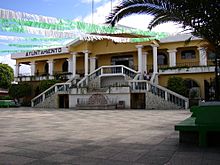
Townhall of Santiago Sacatépéquez
|
|
| Country | |
| Department | Sacatepéquez Department |
| Area | |
| • Total | 13.9 sq mi (36.1 km2) |
| Elevation | 6,690 ft (2,040 m) |
| Population
(2018 census)
|
|
| • Total | 29,238 |
| • Density | 2,097.7/sq mi (809.9/km2) |
| Climate | Cwb |
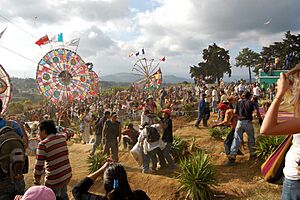
Santiago Sacatepéquez is a town and a municipality in Guatemala. It is part of the Sacatepéquez department. In 2018, about 29,238 people lived there. The town is famous for its big kite festival. This festival happens every year on November 1st.
Contents
History of Santiago Sacatepéquez
Santiago Sacatepéquez is in a valley. Spanish explorers called this area "Valle of Sacatepéquez" in the 1520s. This valley was surrounded by other areas. These included Xilotepeque to the west and Mixco to the north.
In the 1620s and 1630s, an Irish friar named Thomas Gage visited the town. A friar is a member of a religious group. He wrote that Santiago Sacatepéquez was a rich town. It had hundreds of families and a "cold climate."
In the 1540s, a bishop named Francisco Marroquín divided the church's control. He gave different areas to two religious groups. These groups were the Order of Preachers and the Franciscans.
Later, in 1754, a royal order changed things. King Carlos III of Spain made all church areas managed by regular clergy. Regular clergy are priests who belong to religious orders. These areas were then given to secular clergy. Secular clergy are priests who do not belong to a religious order.
In 1766, two nearby areas tried to join. These were Chimaltenango and Sacatepéquez. But their plan did not work out. They stayed separate until Guatemala became independent from Spain in 1821.
Education in Santiago Sacatepéquez
Education is very important in Santiago Sacatepéquez. Here are some facts about how many children attend school:
| Level | Boys | Girls |
|---|---|---|
| Preschool | 52.2 % | 51.7 % |
| Elementary School | 93.1 % | 93.5 % |
| Junior High School | 33.9 % | 28.0 % |
| High School | 1.6 % | 1.2 % |
| Boys | Girls |
|---|---|
| 89.8% | 73.8% |
| City Areas | Rural Areas |
|---|---|
| 25% | 53% |
These tables show how many students are in school. They also show how many people can read and write. For example, 93.5% of girls attend elementary school.
Climate and Weather
Santiago Sacatepéquez has a special type of weather. It is called a subtropical highland climate. This means it is usually mild, not too hot or too cold. It also has wet and dry seasons.
| Climate data for Santiago Sacatepéquez | |||||||||||||
|---|---|---|---|---|---|---|---|---|---|---|---|---|---|
| Month | Jan | Feb | Mar | Apr | May | Jun | Jul | Aug | Sep | Oct | Nov | Dec | Year |
| Mean daily maximum °C (°F) | 20.2 (68.4) |
21.4 (70.5) |
22.7 (72.9) |
23.5 (74.3) |
22.5 (72.5) |
21.0 (69.8) |
21.0 (69.8) |
21.6 (70.9) |
20.9 (69.6) |
20.3 (68.5) |
20.3 (68.5) |
20.3 (68.5) |
21.3 (70.4) |
| Daily mean °C (°F) | 14.7 (58.5) |
15.5 (59.9) |
16.6 (61.9) |
17.7 (63.9) |
17.5 (63.5) |
17.0 (62.6) |
16.7 (62.1) |
16.9 (62.4) |
16.6 (61.9) |
16.0 (60.8) |
15.4 (59.7) |
14.9 (58.8) |
16.3 (61.3) |
| Mean daily minimum °C (°F) | 9.2 (48.6) |
9.6 (49.3) |
10.5 (50.9) |
11.9 (53.4) |
12.6 (54.7) |
13.0 (55.4) |
12.5 (54.5) |
12.3 (54.1) |
12.4 (54.3) |
11.8 (53.2) |
10.6 (51.1) |
9.6 (49.3) |
11.3 (52.4) |
| Average precipitation mm (inches) | 7 (0.3) |
5 (0.2) |
5 (0.2) |
39 (1.5) |
132 (5.2) |
290 (11.4) |
231 (9.1) |
204 (8.0) |
268 (10.6) |
146 (5.7) |
37 (1.5) |
9 (0.4) |
1,373 (54.1) |
| Source: Climate-Data.org | |||||||||||||
The weather box above shows the average temperatures and rainfall each month. For example, June has the most rain. March is usually the warmest month.
Geographic Location
Santiago Sacatepéquez is located in a specific area. It shares borders with several other towns and municipalities.
 |
San Pedro Sacatepéquez, Guatemala Department municipality Sumpango, Sacatepéquez Department municipality |
 |
||
| Santo Domingo Xenacoj, Sacatepéquez Department municipality | Mixco, Guatemala Department municipality | |||
| San Bartolome Milpas Altas and San Lucas Sacatepéquez, Sacatepéquez Department municipalities |
To the north, you'll find San Pedro Sacatepéquez and Sumpango. To the south are San Bartolome Milpas Altas and San Lucas Sacatepéquez. Mixco is to the east, and Santo Domingo Xenacoj is to the west.
See also
 In Spanish: Santiago Sacatepéquez para niños
 | Calvin Brent |
 | Walter T. Bailey |
 | Martha Cassell Thompson |
 | Alberta Jeannette Cassell |


