Santo Tomé de Zabarcos facts for kids
Quick facts for kids
Santo Tomé de Zabarcos
|
|||
|---|---|---|---|

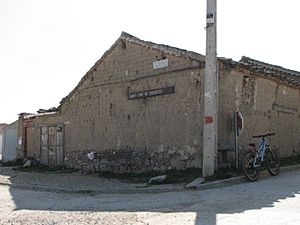
Street of Santo Tomé de Zabarcos
|
|||
|
|||
| Country | |||
| Autonomous community | |||
| Province | |||
| Municipality | Santo Tomé de Zabarcos | ||
| Area | |||
| • Total | 8.42 km2 (3.25 sq mi) | ||
| Elevation | 959 m (3,146 ft) | ||
| Population
(2018)
|
|||
| • Total | 65 | ||
| • Density | 7.72/km2 (19.99/sq mi) | ||
| Time zone | UTC+1 (CET) | ||
| • Summer (DST) | UTC+2 (CEST) | ||
Santo Tomé de Zabarcos is a small town, also known as a municipality (which is like a local government area), located in the province of Ávila. A province is a region, and Ávila is part of a larger area in Spain called Castile and León, which is an autonomous community (like a state or a big region with its own government).
In 2023, a census (a count of all the people) by the INE showed that about 70 people lived in Santo Tomé de Zabarcos. This small town is in the northwest part of Ávila province. It's about 30 kilometers (18 miles) from the main city of Ávila, on the way to Salamanca.
The area where the town is located is called La Morana, which means "Land of the Moors." Two rivers, the Arevalillo and the Zapardiel, flow near the town. These rivers don't have a lot of water, especially in summer when their beds can become dry. However, along their paths, you can find nice groves of trees and green meadows.
How Many People Live Here?
This section shows how the number of people living in Santo Tomé de Zabarcos has changed over many years.
| Historical population | ||
|---|---|---|
| Year | Pop. | ±% |
| 1877 | 255 | — |
| 1887 | 313 | +22.7% |
| 1897 | 323 | +3.2% |
| 1900 | 319 | −1.2% |
| 1910 | 295 | −7.5% |
| 1920 | 314 | +6.4% |
| 1930 | 310 | −1.3% |
| 1940 | 324 | +4.5% |
| 1950 | 369 | +13.9% |
| 1960 | 311 | −15.7% |
| 1970 | 226 | −27.3% |
| 1981 | 167 | −26.1% |
| 1991 | 141 | −15.6% |
| 2001 | 106 | −24.8% |
| 2011 | 111 | +4.7% |
| 2021 | 75 | −32.4% |
See Also
 In Spanish: Santo Tomé de Zabarcos para niños
 | Claudette Colvin |
 | Myrlie Evers-Williams |
 | Alberta Odell Jones |


