Sarfannguit Island facts for kids

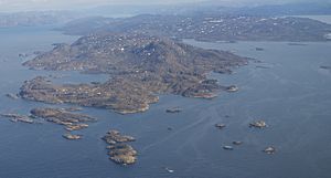
Aerial view of Maniitsorsuaq Island and Sarfannguit Island
|
|
| Geography | |
|---|---|
| Location | Davis Strait |
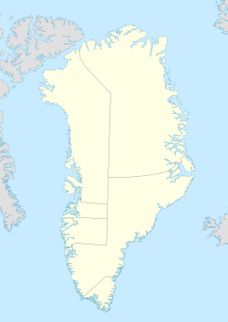
| Coordinates | 66°51′N 53°15′W / 66.850°N 53.250°W |
| Administration | |
| Municipality | Qeqqata |
Sarfannguit Island (also called Sarfannguit Nunataat in Greenlandic or Sarfannguaqland in Danish) is a cool island located in western Greenland. It's part of the Qeqqata municipality and sits right in the Davis Strait. This island is a fascinating place with unique geography and a bit of history!
Contents
Exploring Sarfannguit Island's Geography
Sarfannguit Island has a long, narrow shape. It's separated from the main land of Greenland by a small water path called the Sarfannguit Channel. This channel is found at the eastern tip of the island, where the Sarfannguit village is located.
Waterways Around the Island
To the south, the island is bordered by the Ikertooq Fjord. A fjord is a long, narrow arm of the sea, often with steep cliffs on either side. The Ikertooq Fjord gets much wider as it opens up into the Davis Strait.
What's really interesting is how the Sarfannguit Channel connects two fjords! It links the end of the narrower Amerloq Fjord (which is north of the island) to the larger Ikertooq Fjord in the southeast. It's like a watery shortcut!
Nearby Islands and Historical Sites
West of Sarfannguit Island, along the coast of the Davis Strait, you'll find several smaller islands. The biggest ones are Maniitsorsuaq and Uummannaarsussuaq. There's also a tiny island called Nipisat Island. This small island is special because it has old ruins from early settlements, showing that people lived here a long time ago.
Island's Landscape
Sarfannguit Island is quite hilly. Its highest point reaches about 404 meters (1,325 feet) above sea level. In the past, the coastal areas of the island had several small villages. However, these villages are now empty.
 | Janet Taylor Pickett |
 | Synthia Saint James |
 | Howardena Pindell |
 | Faith Ringgold |


