Schlaiten facts for kids
Quick facts for kids
Schlaiten
|
||
|---|---|---|
|
||

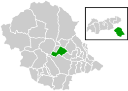
Location within Lienz district
|
||
| Country | Austria | |
| State | Tyrol | |
| District | Lienz | |
| Area | ||
| • Total | 36.64 km2 (14.15 sq mi) | |
| Elevation | 876 m (2,874 ft) | |
| Time zone | UTC+1 (CET) | |
| • Summer (DST) | UTC+2 (CEST) | |
| Postal code |
9954
|
|
| Area code | 4853 | |
| Vehicle registration | LZ | |
Schlaiten is a small village, also known as a municipality, located in the beautiful state of Tyrol in Austria. It is part of the Lienz area. The name Schlaiten probably comes from an old language, called Slavonic. It means "swamp."
This village is made up of several smaller areas or neighborhoods. These include Plone, Gonzach, Mesnerdorf, Bacherdorf, Gantschach, and Göriach.
Population of Schlaiten
This section shows how the number of people living in Schlaiten has changed over many years. It helps us understand the history of the village's size.
| Historical population | ||
|---|---|---|
| Year | Pop. | ±% |
| 1869 | 337 | — |
| 1880 | 339 | +0.6% |
| 1890 | 317 | −6.5% |
| 1900 | 289 | −8.8% |
| 1910 | 302 | +4.5% |
| 1923 | 293 | −3.0% |
| 1934 | 330 | +12.6% |
| 1939 | 323 | −2.1% |
| 1951 | 345 | +6.8% |
| 1961 | 431 | +24.9% |
| 1971 | 447 | +3.7% |
| 1981 | 453 | +1.3% |
| 1991 | 466 | +2.9% |
| 2001 | 498 | +6.9% |
| 2012 | 468 | −6.0% |
See also
 In Spanish: Schlaiten para niños
Black History Month on Kiddle
Outstanding African-Americans
 | Chris Smalls |
 | Fred Hampton |
 | Ralph Abernathy |

All content from Kiddle encyclopedia articles (including the article images and facts) can be freely used under Attribution-ShareAlike license, unless stated otherwise. Cite this article:
Schlaiten Facts for Kids. Kiddle Encyclopedia.


