
Sebastopol, New South Wales facts for kids
Quick facts for kids SebastopolNew South Wales |
|
|---|---|

Entering Sebastopol
|
|

Sebastopol
Location in New South Wales
|
|
| Postcode(s) | 2666 |
| Elevation | 299 m (981 ft) |
| Location |
|
| LGA(s) | Temora Shire |
| County | Clarendon |
| State electorate(s) | Cootamundra |
| Federal Division(s) | Riverina |
Sebastopol is a small village community. It is located in the north-east part of the Riverina region in New South Wales, Australia. The village is about 15 kilometers south of Temora. It is also 19 kilometers north of Junee Reefs.
About Sebastopol
Sebastopol got its name from Sevastopol. This is a city where an important battle happened. The battle took place during the Crimean War. This war was fought a long time ago.
A Bit of History
Gold was found and mined in Sebastopol. This started around the year 1870. The village had its own Post Office. It opened on March 7, 1870. The Post Office stayed open for many years. It finally closed in 1973.
Sebastopol also had a school for children. The school opened in 1871. It taught students for many decades. The school closed its doors in 1949.
Modern Sebastopol
Today, there is a large solar farm near Sebastopol. A solar farm uses sunlight to make electricity. This one covers 248 hectares of land. That's a very big area! It can produce 90 Mega-Watts of power. This solar farm started working in December 2021. It helps provide clean energy for the area.
-
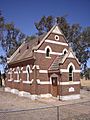
St Stephen's Church Sebastopol
-
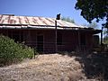
Ruins at Sebastopol


