Secor, Illinois facts for kids
Quick facts for kids
Secor
|
|
|---|---|

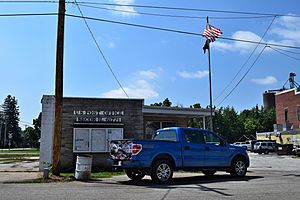
Secor post office
|
|

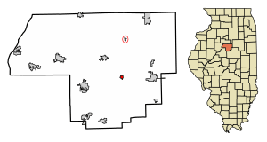
Location of Secor in Woodford County, Illinois.
|
|

Location of Illinois in the United States
|
|
| Country | United States |
| State | Illinois |
| County | Woodford |
| Township | Clayton |
| Area | |
| • Total | 0.29 sq mi (0.75 km2) |
| • Land | 0.29 sq mi (0.75 km2) |
| • Water | 0.00 sq mi (0.00 km2) |
| Elevation | 733 ft (223 m) |
| Population
(2020)
|
|
| • Total | 342 |
| • Density | 1,179.31/sq mi (454.83/km2) |
| Time zone | UTC-6 (CST) |
| • Summer (DST) | UTC-5 (CDT) |
| ZIP Code(s) |
61771
|
| Area code(s) | 309 |
| FIPS code | 17-68510 |
| Wikimedia Commons | Secor, Illinois |
Secor is a small village located in Woodford County, Illinois, in the United States. It's part of the larger Peoria area. In 2020, about 342 people lived here. Secor is easy to find, as it's right off U.S. Route 24, between the towns of El Paso and Eureka.
History of Secor
Secor got its name from a man named Charles A. Secor. He was a partner in an engineering company. This company helped plan and build the eastern part of the Peoria and Oquawka Railroad. That's how the town got its unique name!
Geography of Secor
Secor is located at coordinates 40.741074 degrees North and -89.135875 degrees West. This tells us its exact spot on a map.
According to information from 2010, the village of Secor covers a total area of about 0.3 square miles (0.75 square kilometers). All of this area is land, meaning there are no large lakes or rivers within the village limits.
Population and People of Secor
| Historical population | |||
|---|---|---|---|
| Census | Pop. | %± | |
| 1870 | 407 | — | |
| 1880 | 456 | 12.0% | |
| 1890 | 379 | −16.9% | |
| 1900 | 373 | −1.6% | |
| 1910 | 358 | −4.0% | |
| 1920 | 311 | −13.1% | |
| 1930 | 280 | −10.0% | |
| 1940 | 335 | 19.6% | |
| 1950 | 375 | 11.9% | |
| 1960 | 427 | 13.9% | |
| 1970 | 508 | 19.0% | |
| 1980 | 488 | −3.9% | |
| 1990 | 389 | −20.3% | |
| 2000 | 379 | −2.6% | |
| 2010 | 373 | −1.6% | |
| 2020 | 342 | −8.3% | |
| U.S. Decennial Census | |||
In the year 2000, there were 379 people living in Secor. These people made up 144 households, and 109 of those were families. The village had about 1,069 people per square mile.
Many households in Secor had children under 18 living with them. Most households were married couples living together. Some households were single-parent families, and others were individuals living alone. The average household had about 2.63 people.
The people in Secor were of different ages. About 26.6% were under 18 years old. About 15.3% were 65 years or older. The average age in the village was 38 years old.
In 2000, the average income for a household in Secor was about $44,205 per year. For families, the average income was slightly higher, around $44,722. The average income per person in the village was about $22,635. A small number of families and people in Secor lived below the poverty line.
See also
 In Spanish: Secor para niños
 | Bayard Rustin |
 | Jeannette Carter |
 | Jeremiah A. Brown |

