
Selenography facts for kids

Selenography is the study of the Moon's surface and its physical features. Think of it as making maps of the Moon! In the past, people who studied selenography (called selenographers) spent their time mapping and naming all the different parts of the Moon. This included the dark, flat areas called maria, the round holes called craters, and the mountain ranges.
Most of this mapping work was completed when spacecraft started orbiting the Moon. These missions took many high-resolution pictures of both the side we see and the side we don't. Even so, some areas of the Moon, especially near its poles, still haven't been perfectly photographed. Also, the exact depths of some features, like craters, can still be a bit uncertain. Today, selenography is part of a bigger science called selenology, which is usually just called "lunar science" – the study of everything about the Moon!
Contents
Mapping the Moon's Surface
For a long time, mapping the Moon was a huge challenge. Before spacecraft, astronomers used telescopes to draw what they saw. They carefully sketched the craters, mountains, and flat plains. These early maps helped us understand the Moon's shape and features.
Early Moon Maps
One of the first detailed maps of the Moon was made by Michiel van Langren in 1645. He gave names to many features, often after famous people or places. Soon after, Johannes Hevelius created his own map in 1647. Hevelius used names from Earth's geography, like mountain ranges and seas. These early maps were very important because they were the first attempts to systematically record the Moon's surface.
How Maps Improved
Over the centuries, telescopes got better, and so did the maps. Astronomers like Johann Hieronymus Schröter in the late 1700s made very detailed drawings. They tried to show the height and depth of features. These maps were like the first topographic maps of the Moon. They helped scientists understand how the Moon's surface was formed.
Modern Moon Studies
With the start of the space age, our ability to map the Moon changed completely. Robotic spacecraft could fly close to the Moon and take pictures from orbit. This gave us a much clearer and more accurate view than ever before.
Spacecraft and Imaging
Missions like the Apollo program and later robotic probes provided incredibly detailed images. These pictures helped scientists create precise maps of the entire lunar surface. We learned that the Moon's features are much more rounded than old drawings showed, due to billions of years of impacts. These modern maps are used by scientists today to plan new missions and study the Moon's history.
What We Still Don't Know
Even with all the amazing pictures, there are still parts of the Moon that are not perfectly mapped. The areas near the Moon's north and south poles are especially tricky to photograph from orbit. Scientists are still working to get better images and more accurate measurements of these regions. This ongoing work helps us understand the Moon even better.
Images for kids
-
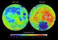
Topography of the Moon, showing its ups and downs.
-
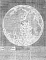
A map of the Moon from 1645 by Michiel van Langren.
-
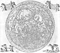
A map of the Moon from 1647 by Johannes Hevelius.
-
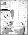
Examples of lunar maps from Johann Hieronymus Schröter's book.
-
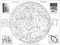
A map of the Moon from an atlas published in 1881.


See also
 In Spanish: Selenografía para niños
