Seymour, Tennessee facts for kids
Quick facts for kids
Seymour
|
|
|---|---|

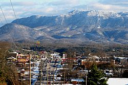
Seymour, with Chapman Highway on the left, and Bluff Mountain in the distance
|
|
| Motto(s):
"Gorgeous Views, Great People"
|
|

Location of Seymour, Tennessee
|
|
| Country | United States |
| State | Tennessee |
| Counties | Sevier, Blount |
| Area | |
| • Total | 16.03 sq mi (41.51 km2) |
| • Land | 16.02 sq mi (41.49 km2) |
| • Water | 0.01 sq mi (0.02 km2) |
| Elevation | 1,211 ft (369 m) |
| Population
(2020)
|
|
| • Total | 14,705 |
| • Density | 917.97/sq mi (354.42/km2) |
| Time zone | UTC-5 (Eastern (EST)) |
| • Summer (DST) | UTC-4 (EDT) |
| ZIP code |
37865
|
| Area code(s) | 865 |
| FIPS code | 47-67200 |
| GNIS feature ID | 2402842 |
Seymour is a community in Tennessee, USA. It is known as a census-designated place (CDP). This means it is a place that looks like a town but doesn't have its own city government. Seymour is located in both Blount and Sevier counties.
In 2020, about 14,705 people lived in Seymour. It is part of the larger Knoxville area.
Contents
Exploring Seymour's History
Early Days: Newell's Station
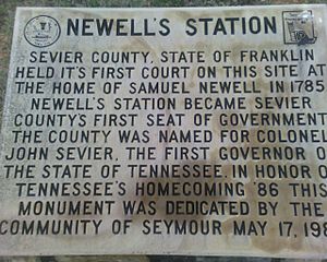
Seymour began as a frontier outpost called Newell's Station. This station was set up in 1783 by an early pioneer named Samuel Newell. It was an important spot for people settling in the area.
The very first court for Sevier County was held here in March 1785. At that time, this area was part of the State of Franklin, which was a short-lived independent territory.
Trundles Crossroads and a New Name
Later, in the 1800s, the community was known as Trundles Crossroads. This was because it was a place where main roads met and split. One road went north to Knoxville, and another went west to Maryville. Today, this spot is where Boyds Creek Highway and Old Sevierville Pike meet.
The community got its current name, Seymour, on December 18, 1909. This happened when the Knoxville, Sevierville and Eastern Railway finished building its train station here. The station was named after Charles Seymour, who was the chief engineer for the railway line. Soon after, the local post office also changed its name to Seymour.
Why Seymour Isn't a City
Over the years, people in Seymour have talked about becoming an official town or city. This process is called "incorporation." If Seymour incorporated, it would have its own local government.
However, most residents have voted against this idea. They worry that becoming a city would mean higher taxes and more government rules. Others believe that having a city government could bring benefits like a community center or new sidewalks. In the end, the community decided to remain unincorporated.
Discovering Seymour's Geography
Location and Landscape
Seymour is located in a beautiful area where the Great Smoky Mountains begin to flatten out. It sits in a rolling valley. To the south, you can see Bluff Mountain, which is part of the Chilhowee Mountain ridge. To the north, the Bays Mountain ridge passes by.
The area of Seymour is about 41.51 square kilometers (about 16.03 square miles). Most of this area is land, with only a tiny bit (0.02 square kilometers or 0.01 square miles) being water.
Major Roads and Connections
Chapman Highway runs through Seymour. This road connects Seymour to Knoxville in the northwest.
In the middle of Seymour, Chapman Highway meets U.S. Route 411 and Boyds Creek Highway (State Route 338). U.S. Route 411 comes from Maryville to the west. Boyds Creek Highway comes from Boyds Creek to the east. After this intersection, Chapman Highway and U.S. Route 411 continue together towards Sevierville.
Understanding Seymour's Population
| Historical population | |||
|---|---|---|---|
| Census | Pop. | %± | |
| 2000 | 8,550 | — | |
| 2020 | 14,705 | — | |
| U.S. Decennial Census | |||
Who Lives in Seymour?
In 2020, the 2020 United States census counted 14,705 people living in Seymour. There were 4,403 households and 3,181 families.
Here's a look at the different groups of people living in Seymour in 2020:
| Group | Number | Percentage |
|---|---|---|
| White (not Hispanic or Latino) | 13,310 | 90.51% |
| Black or African American (not Hispanic or Latino) | 118 | 0.8% |
| Native American | 43 | 0.29% |
| Asian | 134 | 0.91% |
| Pacific Islander | 2 | 0.01% |
| Other/Mixed | 659 | 4.48% |
| Hispanic or Latino | 439 | 2.99% |
Education in Seymour
Seymour has several schools, including both private and public options.
Private Schools
- The Kings Academy
- Seymour Community Christian School
Public Schools
Seymour's public schools are part of two different county school systems:
Sevier County Schools
- Seymour Primary (for younger students)
- Seymour Intermediate (for middle-grade students)
- Seymour Junior High (grades 7-9)
- Seymour High (for older students)
Blount County Schools
- Prospect Elementary
See also
 In Spanish: Seymour (Tennessee) para niños


