Sgùrr na Feartaig facts for kids
Quick facts for kids Sgurr na Feartaig |
|
|---|---|

Sgurr na Feartaig
|
|
| Highest point | |
| Elevation | 863 m (2,831 ft) |
| Prominence | 267 m (876 ft) |
| Listing | Corbett, Marilyn |
| Geography | |
| Location | Wester Ross, Scotland |
| Parent range | Northwest Highlands |
| OS grid | NH055453 |
| Topo map | OS Landranger 25 |
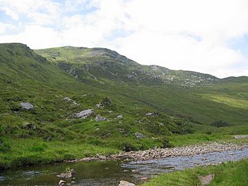
Sgurr na Feartaig is a mountain found in the beautiful Northwest Highlands of Scotland. It stands 863 meters (about 2,831 feet) tall. This mountain is located in an area called Wester Ross, which is northeast of a village named Strathcarron.
What is Sgurr na Feartaig?
Sgurr na Feartaig is a mountain that looks like a long, stretched-out ridge. A ridge is a chain of hills or mountains that forms a continuous elevated crest. This long shape makes it a very noticeable feature on the southern side of Glen Carron. Glen Carron is a valley where the River Carron flows.
Mountain Classifications
Sgurr na Feartaig is known by two special mountain classifications in Scotland:
- Corbett: This means it is a Scottish mountain between 2,500 and 3,000 feet (762 and 914.4 meters) high. It must also have a "prominence" of at least 500 feet (152.4 meters). Prominence means how much a mountain rises from the land around it.
- Marilyn: This is a hill or mountain in the British Isles that has a prominence of at least 150 meters (about 492 feet). Sgurr na Feartaig fits this description too.
These classifications help hikers and climbers identify different types of mountains. They also help people keep track of how many mountains they have climbed!
 | Anna J. Cooper |
 | Mary McLeod Bethune |
 | Lillie Mae Bradford |

