Shariatpur District facts for kids
Quick facts for kids
Shariatpur
শরিয়তপুর
|
|
|---|---|
| Shariatpur | |

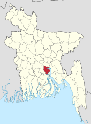
Location of Shariatpur in Bangladesh
|
|
| Country | |
| Area | |
| • Total | 1,181.53 km2 (456.19 sq mi) |
| Population
(2011 census)
|
|
| • Total | 1,155,824 |
| • Density | 978.243/km2 (2,533.639/sq mi) |
| Time zone | UTC+06:00 (BST) |
| Postal code |
8000
|
| Website | http://www.shariatpur.gov.bd/ |
Shariatpur is a district located in the Dhaka Division of central Bangladesh. It is a place with many rivers and green landscapes. The district is named after a famous Islamic reformer, Haji Shariatullah.
Shariatpur is surrounded by other districts. To the north, you'll find Munshiganj. To the south is Barisal district. Chandpur district is to the east, and Madaripur district is to the west.
Contents
Geography and Rivers
Shariatpur is known for its many important rivers. The main rivers flowing through the district are the Padma, the Meghna, the Palong, and the Jayanti. These rivers are very important for the people living here. They help with transportation, farming, and fishing.
Area and Subdivisions
The district covers a total area of about 1,181.53 square kilometers. Shariatpur is divided into six smaller areas called upazilas. An upazila is like a sub-district.
- Bhedarganj Upazila is the largest of these upazilas, covering about 311.24 square kilometers.
- Damudya Upazila is the smallest, with an area of about 91.76 square kilometers.
These upazilas help manage the different parts of the district.
People and Life
According to the 2011 census, about 1,155,824 people live in Shariatpur district. Most people in the district live in rural areas. They often work in farming and fishing. The rivers play a big role in their daily lives.
Farming and Economy
Agriculture is a very important part of the economy in Shariatpur. The fertile land near the rivers is great for growing crops. Farmers grow rice, jute, and various vegetables. Fishing is also a major activity, with the rivers providing plenty of fish.
Education and Culture
Like other parts of Bangladesh, Shariatpur has schools and colleges. Education is important for the children and young people here. The culture of Shariatpur is similar to the broader Bengali culture, with traditional festivals and customs.
History of Shariatpur
Shariatpur district was officially formed in 1984. Before that, it was part of the Madaripur district. The area has a rich history, influenced by its rivers and agricultural lands. It has always been an important region for trade and farming due to its location near major waterways.
The district's name honors Haji Shariatullah, a significant figure in the 19th century. He worked to improve the lives of people and promote Islamic values in the region.
See also
 In Spanish: Shariatpur (zila) para niños
 | Bessie Coleman |
 | Spann Watson |
 | Jill E. Brown |
 | Sherman W. White |

