Sharon Springs, Kansas facts for kids
Quick facts for kids
Sharon Springs, Kansas
|
|
|---|---|
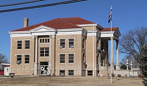
Wallace County Courthouse (2010)
|
|
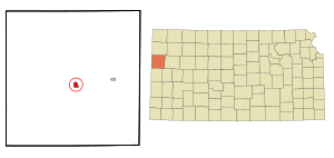
Location within Wallace County and Kansas
|
|
|
|
| Country | United States |
| State | Kansas |
| County | Wallace |
| Founded | 1868 |
| Incorporated | 1890 |
| Named for | Sharon Springs, New York |
| Area | |
| • Total | 0.90 sq mi (2.34 km2) |
| • Land | 0.90 sq mi (2.34 km2) |
| • Water | 0.00 sq mi (0.00 km2) |
| Elevation | 3,442 ft (1,049 m) |
| Population
(2020)
|
|
| • Total | 751 |
| • Density | 834/sq mi (320.9/km2) |
| Time zone | UTC-7 (Mountain (MST)) |
| • Summer (DST) | UTC-6 (MDT) |
| ZIP code |
67758
|
| Area code | 785 |
| FIPS code | 20-64375 |
| GNIS ID | 2395858 |
| Website | Info |
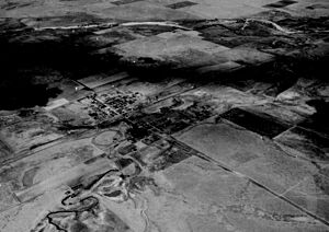
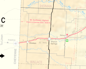
Sharon Springs is a city located in Wallace County, Kansas, in the United States. It's also the county seat, which means it's where the main government offices for Wallace County are. In 2020, about 751 people lived there.
Contents
History of Sharon Springs
Sharon Springs started as a place called Eagle Tail station in 1868. Later, in 1886, its name was changed to Sharon Springs. This new name came from a town called Sharon Springs, New York. The community officially became a city in 1890.
In 2013, a very large hole, called a sinkhole, appeared north of Sharon Springs. By December 2013, this sinkhole was about 88 feet (27 meters) deep. It was also about 243 feet (74 meters) wide.
On April 22, 2022, a strong tornado hit the city. This tornado was rated as a high-end EF1. It caused a lot of damage to buildings and other parts of the city.
Geography and Climate
According to the United States Census Bureau, Sharon Springs covers an area of about 0.91 square miles (2.36 square kilometers). All of this area is land, with no water.
Climate in Sharon Springs
Sharon Springs has a semi-arid climate. This means it's generally dry, but not as dry as a desert. It gets some rain, but not a lot. This type of climate is often shown as "BSk" on climate maps.
| Climate data for Sharon Springs, Kansas, 1991–2020 normals, extremes 1893–present | |||||||||||||
|---|---|---|---|---|---|---|---|---|---|---|---|---|---|
| Month | Jan | Feb | Mar | Apr | May | Jun | Jul | Aug | Sep | Oct | Nov | Dec | Year |
| Record high °F (°C) | 85 (29) |
82 (28) |
90 (32) |
98 (37) |
103 (39) |
112 (44) |
109 (43) |
110 (43) |
106 (41) |
100 (38) |
92 (33) |
82 (28) |
112 (44) |
| Mean maximum °F (°C) | 67.4 (19.7) |
70.5 (21.4) |
80.3 (26.8) |
87.2 (30.7) |
94.2 (34.6) |
101.3 (38.5) |
102.8 (39.3) |
100.8 (38.2) |
96.9 (36.1) |
89.3 (31.8) |
77.2 (25.1) |
66.8 (19.3) |
104.1 (40.1) |
| Mean daily maximum °F (°C) | 43.7 (6.5) |
46.1 (7.8) |
56.5 (13.6) |
64.9 (18.3) |
74.5 (23.6) |
86.3 (30.2) |
91.2 (32.9) |
88.4 (31.3) |
80.9 (27.2) |
67.8 (19.9) |
54.2 (12.3) |
44.1 (6.7) |
66.6 (19.2) |
| Daily mean °F (°C) | 30.5 (−0.8) |
32.7 (0.4) |
42.1 (5.6) |
50.8 (10.4) |
61.2 (16.2) |
72.4 (22.4) |
77.7 (25.4) |
75.2 (24.0) |
66.9 (19.4) |
53.1 (11.7) |
40.4 (4.7) |
31.4 (−0.3) |
52.9 (11.6) |
| Mean daily minimum °F (°C) | 17.3 (−8.2) |
19.4 (−7.0) |
27.8 (−2.3) |
36.7 (2.6) |
47.9 (8.8) |
58.6 (14.8) |
64.1 (17.8) |
62.0 (16.7) |
52.9 (11.6) |
38.4 (3.6) |
26.5 (−3.1) |
18.6 (−7.4) |
39.2 (4.0) |
| Mean minimum °F (°C) | −0.6 (−18.1) |
3.0 (−16.1) |
10.4 (−12.0) |
21.6 (−5.8) |
33.1 (0.6) |
46.0 (7.8) |
55.2 (12.9) |
52.6 (11.4) |
38.7 (3.7) |
22.1 (−5.5) |
10.3 (−12.1) |
1.6 (−16.9) |
−5.7 (−20.9) |
| Record low °F (°C) | −20 (−29) |
−23 (−31) |
−18 (−28) |
8 (−13) |
21 (−6) |
33 (1) |
41 (5) |
44 (7) |
22 (−6) |
6 (−14) |
−8 (−22) |
−22 (−30) |
−23 (−31) |
| Average precipitation inches (mm) | 0.40 (10) |
0.59 (15) |
0.95 (24) |
1.80 (46) |
2.58 (66) |
2.77 (70) |
3.86 (98) |
2.96 (75) |
1.57 (40) |
1.27 (32) |
0.65 (17) |
0.45 (11) |
19.85 (504) |
| Average snowfall inches (cm) | 3.2 (8.1) |
4.7 (12) |
3.3 (8.4) |
1.4 (3.6) |
0.1 (0.25) |
0.0 (0.0) |
0.0 (0.0) |
0.0 (0.0) |
0.1 (0.25) |
1.4 (3.6) |
2.3 (5.8) |
4.5 (11) |
21.0 (53) |
| Average precipitation days (≥ 0.01 in) | 2.3 | 2.4 | 3.3 | 4.9 | 6.6 | 6.3 | 7.0 | 6.6 | 3.3 | 3.8 | 2.8 | 2.3 | 51.6 |
| Average snowy days (≥ 0.1 in) | 1.6 | 1.9 | 1.3 | 0.5 | 0.0 | 0.0 | 0.0 | 0.0 | 0.0 | 0.3 | 1.1 | 1.9 | 8.6 |
| Source 1: NOAA | |||||||||||||
| Source 2: National Weather Service | |||||||||||||
People of Sharon Springs
The number of people living in Sharon Springs has changed over the years. This information comes from the U.S. Census, which counts everyone in the country every ten years.
| Historical population | |||
|---|---|---|---|
| Census | Pop. | %± | |
| 1890 | 178 | — | |
| 1900 | 180 | 1.1% | |
| 1910 | 440 | 144.4% | |
| 1920 | 815 | 85.2% | |
| 1930 | 792 | −2.8% | |
| 1940 | 760 | −4.0% | |
| 1950 | 994 | 30.8% | |
| 1960 | 966 | −2.8% | |
| 1970 | 1,012 | 4.8% | |
| 1980 | 982 | −3.0% | |
| 1990 | 872 | −11.2% | |
| 2000 | 835 | −4.2% | |
| 2010 | 748 | −10.4% | |
| 2020 | 751 | 0.4% | |
| U.S. Decennial Census | |||
2010 Census Information
In 2010, the census showed that 748 people lived in Sharon Springs. There were 327 households, which are groups of people living together in one home. About 197 of these households were families.
Most of the people in the city were White (94.5%). A smaller number were from other racial backgrounds or more than one race. About 5.7% of the population identified as Hispanic or Latino.
About 27.2% of the households had children under 18 living there. Many households (51.7%) were married couples living together. The average household had 2.23 people, and the average family had 2.99 people.
The average age of people in Sharon Springs was 45.3 years old. About 25.5% of residents were under 18. About 25% of residents were 65 years old or older. The city had slightly more females (51.2%) than males (48.8%).
Education in Sharon Springs
Students in Sharon Springs go to schools run by the Wallace County USD 241 public school district. This district serves the community's educational needs.
Transportation in Sharon Springs
Sharon Springs is located right on U.S. Route 40. This is an important road that helps people travel to and from the city.
See also
 In Spanish: Sharon Springs (Kansas) para niños
 | Delilah Pierce |
 | Gordon Parks |
 | Augusta Savage |
 | Charles Ethan Porter |


