Sheep Creek (Juneau, Alaska) facts for kids
Quick facts for kids Sheep Creek (Juneau, Alaska) |
|
|---|---|

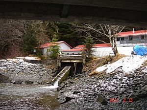
Sheep Creek Hatchery, as seen from beneath the bridge carrying Thane Road over Sheep Creek
|
|
| Lua error in Module:Location_map at line 420: attempt to index field 'wikibase' (a nil value).
Location of the mouth of Sheep Creek in Alaska
|
|
| Native name | Sheep Creek |
| Country | United States |
| State | Alaska |
| Physical characteristics | |
| Main source | 58°15′40″N 134°19′23″W / 58.26111°N 134.32306°W |
| Length | 3.5 km (2.2 mi) |
| Basin features | |
| Basin size | 5 km2 (1.9 sq mi) |
Sheep Creek is a small river located about 4 miles (6.4 km) southeast of Juneau, in the state of Alaska. It flows into the Gastineau Channel. The area around the creek was once known as Sheep Creek, before it became the community of Thane.
The creek's valley has a flat, gravel trail that is about 3.5 miles (5.6 km) long. This trail is south of Mount Roberts. You can also find a substation for the Snettisham hydroelectric dam along a path connected to the main trail. Near where the creek flows out, there is a special place called the Sheep Creek Hatchery.
Contents
Exploring Sheep Creek's Geography
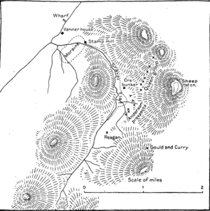
Sheep Creek starts high up on Sheep Mountain, at an elevation of about 4,238 feet (1,292 meters). It flows from a water divide near Grindstone Creek. The main part of the valley runs from the southeast to the northwest.
The River's Path
About 2 miles (3.2 km) from its start, the stream makes a wide turn. For the last 1.5 miles (2.4 km) of its journey, it flows towards the southwest. The entire river valley is about 3.5 miles (5.6 km) long. The beginning and end parts of the creek have steep slopes. However, the middle section flows over a flat, gravel area. This gravel area slopes from about 700 feet (213 meters) down to 550 feet (168 meters) in elevation.
Below the gravel flat, the smaller streams that feed into Sheep Creek are very narrow. There are no side valleys or "gulches" there. Most of the water that drains into Sheep Creek comes from its upper basin. Here, the valley walls are steep. They are covered with alder bushes and grass up to about 1,800 feet (549 meters) high. The surrounding ridges are generally smooth and show signs of being shaped by ice long ago.
The Sheep Creek Trail
The gravel trail along Sheep Creek is 3.5 miles (5.6 km) long. It connects to other trails like the Mount Juneau Trail, the Granite Creek Trail, and the Red Mill Trail. Many smaller paths branch off from it, leading to scenic viewpoints and old mine ruins. This trail is wide and made of gravel, so it's not muddy or slippery. This makes it easy and safe to walk on.
Understanding Sheep Creek's Geology
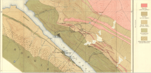
The rock formations found at Gold Creek continue all the way southeast to Taku Inlet. However, Sheep Creek only cuts through two main types of these rocks. These are black slate and a group of green stones mixed with slate.
On the ridge between Gold Creek and Sheep Creek, the band of slates is about 6,800 feet (2,073 meters) wide. This width doesn't change much near the Grindstone Creek divide, which is 3.5 miles (5.6 km) away. The black slates contain dikes, which are like walls of dark diorite rock. These dikes follow the general direction of the rock formation.
On the southeast ridge of Sheep Mountain, there is an irregular dike of diorite rock. This rock has some sulphides, which are minerals containing sulfur. It also has small veins of quartz. This rock formation cuts through an older dike of dark diorite.
Animals and Plants of Sheep Creek
The Sheep Creek valley is home to many interesting plants and animals.
Plant Life
You can find many types of berries in the valley. These berries are an important food source for bears. Other notable plants include wild geranium, columbine, and "shooting stars" (Dodecatheon). You might also see "chocolate lilies" (Fritillaria affinis), blueberry bushes, and salmonberry bushes.
Animal Life and Salmon Life Cycle
The valley is home to mountain goats and black bears. In late summer, the creek becomes packed with chum salmon (also known as dog salmon). These fish, scientifically called Oncorhynchus keta, fill the stream from bank to bank. It's a popular spot to watch the salmon and even go fishing.
The Sheep Creek Hatchery was built in 1980. Its main goal was to help about 40 million pink and chum salmon grow for commercial fishing. Later, the Coho Annex facility joined the hatchery to provide coho fish for breeding. Over the years, this expanded into the Macaulay Salmon Hatchery, which now focuses on raising coho salmon.
 | Jewel Prestage |
 | Ella Baker |
 | Fannie Lou Hamer |


